Hurricane Irma

The friendliest place on the web for anyone who enjoys boating.
If you have answers, please help by responding to the unanswered posts.
Can you imagine living 75-100 years ago, when you'd have very little advance notice, if any, of something like this ? ( The first weather satellite was launched in 1960 )

yes true :hide:

they was living on small houses easy to close rapidly
 
Can you imagine living 75-100 years ago, when you'd have very little advance notice, if any, of something like this ? ( The first weather satellite was launched in 1960 )

I thought of that earlier. And television and news. It wasn't nearly that long ago that many of the other countries and islands got no advanced warning. Even Haiti in their recent flood, a sizable percentage of their population had no advance warning. It's a terrible thought to me to be getting hit by something and not knowing what was going on.
 
It's only a 12-1/2 hour drive from Miami to NOLA in normal traffic. Seems like a good excuse to go...this cool front is perfect timing. Plus all the rain from Harvey rinsed the whole place out after a long summer of...well..."life" in the Quarter.
 
i just get some news the eye directly on ST Barth

this is totally apocalyptic every place they are survival mode

fire station under 3 feet of water

the office of emergency general organisation is out of order

totally disaster
 
I think we can all appreciate the hard work and skill involved in the forecasting - and the importance of being conservative - but Its interesting to me NOAA and the other providers don't publish information about their historical accuracy. Just looking a wind probabilities, the sheer area even at 20% probability appears to be 100 to 1000 times as large as the actual area that will be affected.
 
I think we can all appreciate the hard work and skill involved in the forecasting - and the importance of being conservative - but Its interesting to me NOAA and the other providers don't publish information about their historical accuracy. Just looking a wind probabilities, the sheer area even at 20% probability appears to be 100 to 1000 times as large as the actual area that will be affected.

But you cant look just at area, you have to look at how far off a given track the percentages are. Its the deviation that matters, not the area swept out. The areas are just probabilities should the forecast be way off.

The forecast areas seem very similar to search areas for a lost boat. Put in terms I understand, yet probably similar to storm forcasting because of weather factors affecting a drifting boat/person (which are even usually different) As the uncertainty of drift direction goes on with time, the probability cones get wider and wider even if your estimates are only a few degrees off. Nothing majical, just math.
 
.....but Its interesting to me NOAA and the other providers don't publish information about their historical accuracy......


They seem pretty transparent about it. The following statement is included in the discussion notes:

"Users are reminded to not focus on the exact forecast track,
especially at the longer ranges, since the average NHC track errors
are about 175 and 225 statute miles at days 4 and 5, respectively."
 
We are halfway up the ICW. Spending the night in Waca Wachie tonight then 4 more hours tomorrow to Grande Dunes. A buddy of mine came with me and we are having a blast. But tomorrow how should I leave the boat? As many bumpers and lines that I have, but what about shore power? I'm thinking no shore power and empty the fridge and leave it open. Should I tie the boat tight to the floating docks or loose?

Steve- Grand Dunes should be a good place to hole up. It should get little surge up there, but the current in the center of the ICW could get very strong. Try to get an inside slip vs tying up on the face dock. The ditch is narrow, but if wind aligns with it, it will get rough. Boats on the face dock could get beat.

I think the piles for the floating docks are pretty high, so the floaters should be safe. Try to get in a slip where you can tie to both sides and stretch boat between the floaters. Even tie to the boat next to you if applicable.

Tie tight to floaters, tie loose to piles. Dockhands there should know the drill and give you good guidance.

Yep, empty the fridge, keep shore power and charger on, check all bilge pumps by flipping the floats.
 
For what it's worth this cool front is moving through Houston now. If it hurries across the Gulf that might push Irma east...
 
My boat is up on the hard over at Lambs Yacht Center, all the work now completed. They are starting to lift all of their hurricane contracted boats tomorrow morning. Which means Sonas will be stuck back there until they are all put back in.
So I told them to launch her first thing tomorrow and I will come get her. She is safer here with me.
 
I note Richard Branson is staying put in his multi million dollar island bunker and blaming climate change for Irma's potential ferocity. Politics as usual will get involved.

Good to see Harvey remediation efforts are dealing with fixing things as opposed to Katrina style finger pointing. Hopefully Irma's long lead time notifications will keep the "whose to blame" nonsense to a minimum.

I believe this is the first mention of politics in this thread.

Congrats.
 
Yeah really. I know I'm probably the pot calling the kettle black here, but let's try to leave politics out of this and focus on helping fellow boaters who need help with this storm.

Now who wants to drive to the center of Florida let my jib down for me? [emoji23]
 
This got me looking up record non tornado surface wind speeds. Not a record I'd like to come near :eek:

"The fastest wind speed not related to tornadoes ever recorded was during the passage of Tropical Cyclone Olivia on 10 April 1996: an automatic weather station on Barrow Island, Australia, registered a maximum wind gust of 408 km/h (220 kn; 253 mph; 113 m/s)"

Wikipedia
 
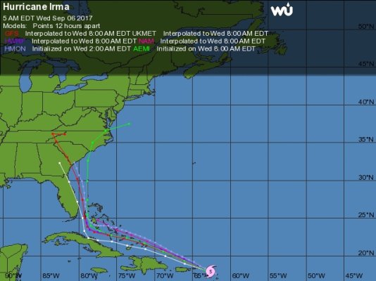
Storm track projection moving east.
Potentially coming into Carolinas or even Virginia where I am.
Very uncertain where it decides to hit . Could make multiple landfalls off our coasts.
models_storm1.jpg
 
This got me looking up record non tornado surface wind speeds. Not a record I'd like to come near :eek:

"The fastest wind speed not related to tornadoes ever recorded was during the passage of Tropical Cyclone Olivia on 10 April 1996: an automatic weather station on Barrow Island, Australia, registered a maximum wind gust of 408 km/h (220 kn; 253 mph; 113 m/s)"

Wikipedia

on news yesterday on Weather Channel, Irma had wind gusts of 212 mph as recorded from the hurricane tracking airplane. I think that would blow you right off your feet into the air.
 
I like my spaghetti better

IMG_0926.JPG
 
I believe this is the first mention of politics in this thread.

Congrats.

As you mentioned in a previous post, hotel sex during a hurricane is worth talking about. That said, if you take the time to read what Richard Branson is posting on his Island's preparations some things can be learned. Many things.
 
Last edited:
As you mentioned in a previous post, hotel sex during a hurricane is worth talking about. That said, if you take the time to read what Richard Branson is posting on his Island's preparations some things can be learned. Many things.

Just leave it would you. Or go start a separate thread in OTDE.
 
I went to Marathon yesterday and took my boat out of the water. I just finished putting up the storm shutters on my house here in Homestead.

I am considering leaving tonight but there is no fuel in the gas stations here at the moment. I have a full tank in my truck which will take me about 300 miles. With all the people leaving and the real possibility of more forced evacuations I wonder if there will be enough fuel on the road.

I live about a 1.5 miles inland and there are no other houses between and the ocean.

I am not sure what will be safer???

Billy
 
"I am not sure what will be safer???"

What will your front yard look like if the ocean rises 10-15 or 20 ft?

Feet dry ? , not much debris to be airborne nearby , you should be fine if living sans electric is no problem.
 
I went to Marathon yesterday and took my boat out of the water. I just finished putting up the storm shutters on my house here in Homestead.

I am considering leaving tonight but there is no fuel in the gas stations here at the moment. I have a full tank in my truck which will take me about 300 miles. With all the people leaving and the real possibility of more forced evacuations I wonder if there will be enough fuel on the road.

I live about a 1.5 miles inland and there are no other houses between and the ocean.

I am not sure what will be safer???

Billy

Have any orders been issued for your area? I'd suggest locating your home on this map as part of your decision.

https://www.miamidade.gov/fire/library/evacuation-zone-map.pdf

Zones A and B are the ones that may be issued evacuation orders.

I believe most, if not all of Homestead is in a Zone A or B. Indication is evacuation orders may be issued later today or tomorrow morning.

Only you can know what is right for you, but if you're ordered to evacuate, it probably makes sense to do so. The issue is where to go. Shelters will be set up and may be the best choice unless you have friends or family in safer zones. Hotels are going to be problematic on the evacuation route. I don't know how fuel will be. I'd think better availability the further you go but perhaps long lines. It appears you have enough fuel to make it to Orlando?

You can sign up here for alerts:

Miami-Dade County - Alerts - Welcome to Miami-Dade Alerts
 
"I am not sure what will be safer???"

What will your front yard look like if the ocean rises 10-15 or 20 ft?

Feet dry ? , not much debris to be airborne nearby , you should be fine if living sans electric is no problem.

Here is a map that shows expected surge in your area based on hurricane Category. In your area you will see that at CAT 1, you're talking up to 3', at CAT 3 you're up to 9' and at CAT 5 you're over 9'.

http://noaa.maps.arcgis.com/apps/MapSeries/index.html?appid=d9ed7904dbec441a9c4dd7b277935fad&entry=1
 
Wifey B: Boy these things give you such mixed feelings. I don't want it hitting me, but I don't want it hitting anyone.

There's a bunch of people down here feeling the same way. Subject of some discussion in my circle. Wishing it doesn't come here, while knowing that means some other poor person is going to get it in the neck. I rationalize it by knowing that if you live on the SE or Gulf coast long enough, you're going to get your turn in the barrel.
 
I went to Marathon yesterday and took my boat out of the water. I just finished putting up the storm shutters on my house here in Homestead.

I am considering leaving tonight but there is no fuel in the gas stations here at the moment. I have a full tank in my truck which will take me about 300 miles. With all the people leaving and the real possibility of more forced evacuations I wonder if there will be enough fuel on the road.

I live about a 1.5 miles inland and there are no other houses between and the ocean.

I am not sure what will be safer???

Billy

Make some phone calls. You may find gas more easily going across on Interstate 75 and up the West Coast.

Ted
 
Benthic (re: post 119) - here's a good read on the Galvestion hurricane of 1900 that speaks to the state of the art in those days: Isaac's Storm: A Man, a Time, and the Deadliest Hurricane in History; Erik Larson
 
Back
Top Bottom