You are using an out of date browser. It may not display this or other websites correctly.
You should upgrade or use an alternative browser.
You should upgrade or use an alternative browser.
How can a moored boat be moving?
- Thread starter Hawgwash
- Start date
The friendliest place on the web for anyone who enjoys boating.
If you have answers, please help by responding to the unanswered posts.
If you have answers, please help by responding to the unanswered posts.
Capt.Bill11
Guru
Tied to a dock, mooring or at anchor?
All tied up at a dock. Engines down. No other stationary vessel I can find on AIS shows that.Tied to a dock, mooring or at anchor?
O C Diver
Guru
- Joined
- Dec 16, 2010
- Messages
- 12,865
- Location
- USA
- Vessel Name
- Slow Hand
- Vessel Make
- Cherubini Independence 45
Simply, if the system isn't malfunctioning, either the boat is moving back and forth quickly (not tight to the dock) or the GPS antenna is moving around. If you watch the AIS display, the heading of the boat should be changing if it's moving back and forth.
Ted
Ted
That makes sense, Ted. Direction does not change because there is not enough heading change. It is very tidal with wide river outflow speed and current shifts. I guess it could be working on the lines like a bungee with the current. Interesting. Two other boats nearby show a constant 0 speed.Simply, if the system isn't malfunctioning, either the boat is moving back and forth quickly (not tight to the dock) or the GPS antenna is moving around. If you watch the AIS display, the heading of the boat should be changing if it's moving back and forth.

Capt.Bill11
Guru
I thought you were looking at AIS on your plotter.
There is a difference between what you'd see on the AIS on your plotter in real time and what you're seeing on an AIS site like Marine Traffic I'll bet.
There is a difference between what you'd see on the AIS on your plotter in real time and what you're seeing on an AIS site like Marine Traffic I'll bet.
Could be but either way you wouldn't think it would show movement when it has been fast to the dock for days.Capt.Bill11; said:There is a difference between what you'd see on the AIS on your plotter in real time and what you're seeing on an AIS site like Marine Traffic I'll bet.

twistedtree
Guru
Normal GPS error will result in more or less random COG and SOG when standing still. Some GPSs do averaging so they mostly report zero SOG when anchored or moored, but not all do.
psneeld said:some GPS inputs do jump around a lot while sitting still...
There we go. 'Splains a lot.twistedtree; said:Normal GPS error will result in more or less random COG and SOG when standing still. Some GPSs do averaging so they mostly report zero SOG when anchored or moored, but not all do.

markpierce
Master and Commander
- Joined
- Sep 25, 2010
- Messages
- 12,557
- Location
- USA
- Vessel Name
- Carquinez Coot
- Vessel Make
- penultimate Seahorse Marine Coot hull #6
Observed an AIS signal moving east at 60 mph. It was crossing the Richmond-to-Marin-County bridge (SW end of San Pablo Bay). Concluded the vessel was being towed by a land vehicle.
Hawg
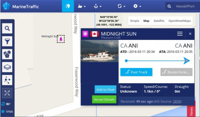
I have been watching Midnight Sun move around on shore close to her shelter in the Fraser over the last few weeks. May be something that being covered by the shelter roof is doing to the signal? I'll let the owner know, as he is a friend of mine and it is time I called.
I have been watching Midnight Sun move around on shore close to her shelter in the Fraser over the last few weeks. May be something that being covered by the shelter roof is doing to the signal? I'll let the owner know, as he is a friend of mine and it is time I called.
Funny only those two showed movement.Hawg
I have been watching Midnight Sun move around on shore close to her shelter in the Fraser over the last few weeks. May be something that being covered by the shelter roof is doing to the signal? I'll let the owner know, as he is a friend of mine and it is time I called.
I know you can't answer this but, why do so many folks leave the AIS on while it's in the nest? Do they set the alarm and wake up at 3am to see if it's still there?
- Joined
- Apr 15, 2008
- Messages
- 13,731
- Location
- California Delta
- Vessel Name
- FlyWright
- Vessel Make
- 1977 Marshall Californian 34 LRC
Hawgwash and markpierce, I think you're confusing AIS with an online lookalike such as marinetraffic or boatbeacon. Those online versions have serious delays and inaccuracies. I wouldn't trust them like one could trust a real AIS. But even with a real AIS, it's just smart to cross reference with other sources like radar, eyeballs, etc. In the words of Ronald Reagan, "Trust but verify."
twistedtree
Guru
Funny only those two showed movement.
I know you can't answer this but, why do so many folks leave the AIS on while it's in the nest? Do they set the alarm and wake up at 3am to see if it's still there?
Class A is meant to be left on all the time. They are not equipped with a switch, and the IMO definition of class A AIS says it must be on all the time. There is an exception that allows you to mute transmission for safety, i.e. to not tell the pirates where you are, but it's of marginal value since a radar can see you before AIS can pick you up. But the AIS tells you more about the boat than radar, so there is reason to mute it.
I'm not sure what the spec says for Class B, but thinking about it, the ones I've dealt with don't have on/off switches either. Of course you can cut power to any device, but the absence of a switch suggests how it's intended to be used.
twistedtree
Guru
I too have seen a couple of amusing AIS targets. One appeared to be a duplicate transmission from one of the Washington State Ferries, and I almost called the boat to let them know they seemed to have a problem.... until the ferry docked and the "duplicate" target drove away down the road.... clearly a boat on a trailer with the AIS still on.
Another was a friend who shipped their boat across the atlantic. The AIS was left on (by mistake) and they could track their boat the whole way via one of the sat services.
And last, somewhere in the Seattle area well inland up towards Edmunds someone has a boat parked in their driveway (or maybe it's a land receiver that is also transmitting) called "Simrad". I see it on my plotter anytime I run up/down the sound.
Jay N
Guru
- Joined
- Oct 6, 2007
- Messages
- 502
- Location
- USA
- Vessel Name
- WESTERLY
- Vessel Make
- 1974 Pacific Trawler 37
TwistedTree says: "And last, somewhere in the Seattle area well inland up towards Edmunds someone has a boat parked in their driveway (or maybe it's a land receiver that is also transmitting) called "Simrad". I see it on my plotter anytime I run up/down the sound."
That's Simrad's office in Lynnwood where they have a testing lab.
That's Simrad's office in Lynnwood where they have a testing lab.
No confusion here. I am fully aware of the limitations of the mobile app. due to web technology, older browsers, range, terrestrial vs satellite bla, bla, bla...FlyWright; said:I think you're confusing AIS with an online lookalike such as marinetraffic or boatbeacon. In the words of Ronald Reagan, "Trust but verify."
This is borne out every time I use it in "cross reference with the naked eye" on land and at sea but none of that explains why 2 vessels out of dozens are tossing garbage.
Oh, and Ronald Reagan...he was an actor and a politician, neither of which present things accurately.
A twisted tree is more believable.
If you are seeing the status as "moored" then it is a class A ais signal and position data is uploaded every 180 secs. Twenty snapshots an hour may look like movement in some areas so the "moored" status line is helpful.
Spell check via iPhone.
Spell check via iPhone.
- Joined
- Apr 15, 2008
- Messages
- 13,731
- Location
- California Delta
- Vessel Name
- FlyWright
- Vessel Make
- 1977 Marshall Californian 34 LRC
No confusion here. I am fully aware of the limitations of the mobile app. due to web technology, older browsers, range, terrestrial vs satellite bla, bla, bla..
Are you seeing these aberrations on a Class A or Class B AIS receiver? If so, what model?
Britannia
Wannabe
I can see why marinetraffic.com has delays. But I don't see why it would have inaccuracies. It relies on data sent by reporting stations that receive AIS transmissions. Do those somehow get corrupted before being displayed on marinetraffic?Hawgwash and markpierce, I think you're confusing AIS with an online lookalike such as marinetraffic or boatbeacon. Those online versions have serious delays and inaccuracies. I wouldn't trust them like one could trust a real AIS. But even with a real AIS, it's just smart to cross reference with other sources like radar, eyeballs, etc. In the words of Ronald Reagan, "Trust but verify."
Richard
- Joined
- Apr 15, 2008
- Messages
- 13,731
- Location
- California Delta
- Vessel Name
- FlyWright
- Vessel Make
- 1977 Marshall Californian 34 LRC
Richard, I run marinetraffic and boatbeacon on my tablet while underway. Both have inaccuracies with boats in the wrong position (delay?), boats shown present which are not (ghosting?) present commercial vessels not displayed and docked vessels showing speed which might be from historical data. I've never used a proper AIS.
Capt.Bill11
Guru
it's an app for crying out loud, that relies on 2nd hand data. Is anybody really surprised it's not dead nuts accurate all the time!? 
Aha! Sorta like reading TF, huh?it's an app for crying out loud, that relies on 2nd hand data. Is anybody really surprised it's not dead nuts accurate all the time!?
Britannia
Wannabe
Richard, I run marinetraffic and boatbeacon on my tablet while underway. Both have inaccuracies with boats in the wrong position (delay?), boats shown present which are not (ghosting?) present commercial vessels not displayed and docked vessels showing speed which might be from historical data. I've never used a proper AIS.
Here's my thinking. It's one thing for it to be out of date, it's another for it to publish inaccurate data. After all, these are AIS data packets that are being reported by volunteer stations. They may be delayed, they may be intermittent, but they would need to be corrupted for them to be inaccurate.it's an app for crying out loud, that relies on 2nd hand data. Is anybody really surprised it's not dead nuts accurate all the time!?
The example given here shows that the last update was 41 mins ago. So in all likelihood that vessel was not there when I looked at marinetraffic.com. That doesn't mean it was wrong, just out of date.
I agree that it's not a replacement for an AIS - because it's not real time. I'm just curious if anyone has found it to be inaccurate - like it shows an update from 30 seconds ago and clearly the vessel is not there.
Richard
Attachments

- Joined
- Apr 15, 2008
- Messages
- 13,731
- Location
- California Delta
- Vessel Name
- FlyWright
- Vessel Make
- 1977 Marshall Californian 34 LRC
it's an app for crying out loud, that relies on 2nd hand data. Is anybody really surprised it's not dead nuts accurate all the time!?
You've got that right, Bill!
But it's better than nothing for cheap SOBs like me.
twistedtree
Guru
TwistedTree says: "And last, somewhere in the Seattle area well inland up towards Edmunds someone has a boat parked in their driveway (or maybe it's a land receiver that is also transmitting) called "Simrad". I see it on my plotter anytime I run up/down the sound."
That's Simrad's office in Lynnwood where they have a testing lab.
Ahh, that explains it. Interesting that will all the trouble I had, they never suggested one of those guys drive the 30 minutes to my boat to take a look.

twistedtree
Guru
Just to be clear, we are talking about a vessel that reports a non-zero SOG via AIS when the boat is moored. Right?
On both Class A and Class B AIS the SOG comes from the attached GPS. With Class B it's part of the AIS, and with Class A it's external, with internal as a backup. So the SOG is computed by the GPS and reported by the AIS.
I agree that sites/apps like marinetraffic are unlikely to present anything other than actual AIS data. There is no reason for them to make it up, and internet protocols ensure it's reliable and intact delivery. Delayed, yes, but corrupt, no.
I know if I look at any of my GPSs when standing still, they all report random small SOG values. It's just the nature of the beast. The slower you move, the less accurate the SOG. And when you are standing still, it's utter garbage. Save with COG. This is why some GPSs average/filter to present more "sensible" data when going very slow or at rest.
Similar threads
- Replies
- 31
- Views
- 3K