- Joined
- Oct 1, 2007
- Messages
- 7,331
- Location
- Texas
- Vessel Name
- Floatsome & Jetsome
- Vessel Make
- Meridian 411
Could affect some of you folks on the West Coast. BTY VOR is Reno Nevada.
Probably a non issue but just in case you folks in California or Oregon see weird things going on with your GPS.....
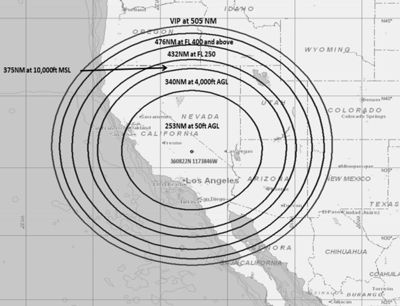
<The FAA has released a Flight Advisory that GPS signals may be unreliable or unavailable between 1630Z–2330Z now through June 30, 2016, due to testing. The testing is centered at 360822N1173846W or the BTY VOR 214 degree radial at 59 NM. Each event may last the entire requested period. Aircrews are encouraged to report anomalies and request ATC assistance if required.
The affected area encompasses a 476 NM radius and covers California, Nevada, Utah, Arizona, and portions of Oregon, Idaho, Wyoming, Colorado, and New Mexico. Affected altitudes will vary from 50 feet to unlimited during test times.
ALPA recommends pilots check NOTAMs frequently for possible changes prior to operations in the area. NOTAMs will be published at least 24 hours in advance of any GPS tests. For more information, please visit the FAA advisory website.>
I see it all the time flying in that area(51) and usually ATC warns us of it. Not a big deal when the FMC can use DME/DME of DME/VOR triangulation. And if not that then it can revert to inertial.
Probably a non issue but just in case you folks in California or Oregon see weird things going on with your GPS.....
<The FAA has released a Flight Advisory that GPS signals may be unreliable or unavailable between 1630Z–2330Z now through June 30, 2016, due to testing. The testing is centered at 360822N1173846W or the BTY VOR 214 degree radial at 59 NM. Each event may last the entire requested period. Aircrews are encouraged to report anomalies and request ATC assistance if required.
The affected area encompasses a 476 NM radius and covers California, Nevada, Utah, Arizona, and portions of Oregon, Idaho, Wyoming, Colorado, and New Mexico. Affected altitudes will vary from 50 feet to unlimited during test times.
ALPA recommends pilots check NOTAMs frequently for possible changes prior to operations in the area. NOTAMs will be published at least 24 hours in advance of any GPS tests. For more information, please visit the FAA advisory website.>
I see it all the time flying in that area(51) and usually ATC warns us of it. Not a big deal when the FMC can use DME/DME of DME/VOR triangulation. And if not that then it can revert to inertial.