Currents up the SF Delta?

The friendliest place on the web for anyone who enjoys boating.
If you have answers, please help by responding to the unanswered posts.

Toki

Senior Member
Joined
Nov 7, 2019
Messages
123
Location
USA
Vessel Name
Toki
Vessel Make
Ranger 27
Hey folks, in a couple weeks I'll be moving my daughter's sailboat from Vallejo up the delta to the Rio Vista area. I'm new to this sort of river travel, and I need to consider that 20 HP motor pushing the lead keel up river (as opposed to 220 HP in my tug!), so I want to time the journey around favorable currents.

I see plenty of info on-line for tides along the way, and I can certainly estimate current direction based on that, but I'm having trouble finding more precise current info; velocity and timing. Up here in the PNW, we have resources like Deepzoom and the Canadian Hydrographic charts that show currents in nice graphical formats.

Question: do any of you bay area-ers know of similar charts or on-line apps showing current time and velocitiy for the delta?

Thanks
 
I have Coastal Explorer on my laptop. It shows currents and direction. Little spendy for one trip.
 
Fortunately for you, the Sacramento River was widened significantly many years ago and that has reduced velocities along your route. What you encounter will primarily be controlled by upstream releases from reservoirs, mitigated by tides. The Delta has several gages throughout but few give velocities. However you can get velocities from the SDI gage on CDEC (http://cdec.water.ca.gov/cdecstation2/).

If you compare the velocity against stage for a similar lunar tidal period you can get some idea of what you will encounter.
 
I use Navionics to plan and monitor tides and currents. It's inexpensive and easy to use. With a slow sailboat, you might be able to 'ride the tide' all the way to Rio Vista if you start early enough in the tide cycle. You can possibly get a 1-1.5 kts push if you time it right.
 
Tides in Rio Vista are about 6 hours apart, If you left at low tide (in Rio Vista) you should get a push most of the way. It depends on the the rivers stage and where in the monthly cycle you travel in (spring or neap tides).

I made the trip from SF to Sacramento several times years ago and found if I left SF at high tide I could get a knot or more almost all the way to Sac if I used the deep water channel. Back then the locks were in operation between the port and the river.

I also was stationed at Mare Island and made the run between the base and Suisun Slough where we had a Vietnam mock up. The outgoing tide can roar thru Carquinez Strait if the rivers are in flood stage and you're in the period of spring tides. We once clocked the ebb at 22 knots. With patrol boats that did 40 knots, it was still an issue.
 
Tide and current (ebb and flood) data

I use this web site to get a handle on tide currents within the Bay:

DeepZoom Nautical Charts Tides and Currents

When you load the site, it will show you an area up in the PNW, but you can zoom out and refocus on the SF Bay. You can change days and time of day to see how the flood and ebb tides and currents progress progress through the bay.

Upstream of Pt. San Pablo, I use the Ayetides app on my iPhone or iPad. The current stations are marked "C" and tide stations are marked "T". The current station closest to Rio Vista is near Sherman Island just downstream of Three-Mile Slough.

I downloaded and plotted a bunch of tide and current data and found that the currents peak about 1.5 hours later than the tide level. This rule of thumb is useful is you can't find a current gauge, since tide gauges are more common.

Have a great trip!
 
Thanks Tom, I use Deepzoom regularly up here in the PNW, and I've used it for sailing in the SF bay too. It does provide current data for the bay proper, but I see no data on currents up the Carquinez Strait and Sac River.

Ayetides is Apple only, I'm all Android, so that doesn't work for me. However, I do use Navionics which provides great tide info, but limited current info up the river.

I'm comfortable basing currents on tides. I'm planning this Transit for 1/25, which looks like an ideal day to leave Vallejo in the morning and ride the current all the way to Rio Vista.

Thanks for the great advice everyone!
 
My experience on the CA Delta is that the further upriver you go, the less accurate and less available the current forecasts get. I figured this is a combination of the downriver flows released from the area dams upstream of the Delta and the throttling effect on upriver currents from the river's straits, forks, sloughs and bends.

One unique characteristic of the Carquinez Strait flows is that the ebb flow persists longer than forecast due to the 'backup' of downstream water in the face of the flood current. The northern areas hold water like a bathtub and it takes longer to drain on the ebb than an unobstructed area would require. This usually means if you leave at the start of the flood in Vallejo, you'll still be fighting strong currents thru Carquinez Strait when you turn the corner leaving Mare Island Strait. I normally wait until 1.5-2 hrs after the forecast current shift to 'ride the tide' upriver.

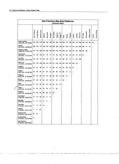
It's a 33 mile trip so if you are able to make 6.5 kts average SOG, it'll take 5 hours. Attached is a handy reference table of SF Bay/CA Delta mileage.
 

Attachments

  • BayDeltaMiles001.jpg
    BayDeltaMiles001.jpg
    95.6 KB · Views: 43
Great to know FlyWright, thanks for the tips.
 
I used to windsurf the Carquinez Bridge when I was younger and crazier and remember some crazy Ebbs and standing waves. A lot of water moving through a narrow area. Watching ships go through there was also fun.
 
I don't sweat it in my six-knot boat. Currents typically rise up to 2.5 knots in the Carquinez Strait. The worse scenario is at the eastern end of Suisun Bay when strong winds oppose the ebb where steep-five-foot waves are encountered, which last time broke my "stateroom" mirror when heading west.

Riding the flood will be a piece of cake.

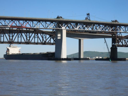
Three bridges at the eastern end of Carquinez Strait:
 

Attachments

  • IMG_1833.jpg
    IMG_1833.jpg
    139.7 KB · Views: 31
Last edited:
I went aground two times in Suisun Bay with my two-foot-draft sailboat. Stay in the channel!
 
I don't sweat it in my six-knot boat. Currents typically rise up to 2.5 knots in the Carquinez Strait. The worse scenario is at the eastern end of Suisun Bay when strong winds oppose the ebb where steep-five-foot waves are encountered, which last time broke my "stateroom" mirror when heading west.

Riding the flood will be a piece of cake.

I lost my 2 1/2 year old professionally-installed rubrail turning the corner W of Port Chicago one balmy July afternoon while proceeding westbound riding a strong ebb. It was one helluva ride as I turned the corner and the prevailing SW wind met the opposing ebb in the shallows by the islands!! It was the proverbial hobby horse ride in an instant. No mud left on that anchor!

When I got home to my slip, I found I was trailing about 30 ft of rubrail off the port corner.

The Delta ain't always benign... but she's always memorable.
 
Figured I'd cap this thread off with an accounting of how my trip up the delta went.

On Saturday I caught the currents perfectly. It took me about 6 hours to motor from Vallejo to the Delta Marina in Rio Vista. A fine but boring trip (single handed, no tiller pilot).

I went into the marina office, told them who I was, and asked for my slip assignment. After a few minutes of the office lady rooting through records, I began to suspect something was amiss. Supposedly my daughter coordinated this all with the marina previously. I showed her the Email communication and she said "That's not us". Turns out my slip was at the Delta Bay Marina, not the Delta Marina.

OK, so it looked like I could cut through "Three Mile Slew" and get to the correct marina in a couple hours right? Not so fast. There's a draw bridge on the slew and it's broken in the closed position.

So ... Sunday involved another 6 hour journey, most of the way back down the delta then up a whole 'nuther set of waterways. I was bucking the current down and riding the current back.

Oh well, I suppose there are worse ways to spend a weekend than putt putting through rivers!
 
My wife and I did a multi-day central Delta cruise in October with our last night at Rio Vista marina. We also got caught on the wrong side of 3-Mile Slough Bridge (also out of operation then) and had to go around the long way. It's virtually impossible to catch favorable tides when going out the San Joaquin and back up the Sacramento. We had a nice cruise though.

My lesson learned from the trip is to read the Coastguard notes and Caltrans notes before the trip.

On another note: my trawler cruises at just under 7 knots. I once exceeded 10.5 knots through Carquinez Straight by catching a flood tide. Fun times.
 
If Rio Vista was full, and we needed a marina, I would have called Vieira's just up the river, back in the day at least they were nice folks. Or continued up to Walnut Grove.
Always helps to have a Plan B. In my case usually a Plan C and D too...
 
Big difference between Delta Marina and Delta Bay Marina. Delta Bay has serious San Joaquin River current flow at times and limited maneuvering room if you're on the levee side of the marina. Also, the prevailing SW wind throws lots of tule reed dust on the boats just about year-round. I spent my first 3-4 months of boat ownership there before I moved abound the corner to Riverboat Marina.

Yes, 3-Mile Slough bridge has been out for a couple of weeks and will probably be down for a couple more. Glad to hear you made it.
 
Back
Top Bottom