dhays
Guru
- Joined
- May 26, 2015
- Messages
- 9,045
- Location
- United States
- Vessel Name
- Kinship
- Vessel Make
- North Pacific 43
Great reporting Dave, thanx.
Bill in Tsehum, off to Sooke tomorrow.
Jealous of your trip Bill.
Great reporting Dave, thanx.
Bill in Tsehum, off to Sooke tomorrow.
Jealous of your trip Bill.
I was going to get some photos of the hull damage, but the owners were removing personal items from the boat so I didn’t want to embarrass them any more than they already must be.
Both a considerate and ethical decision on your part; kudos.
Thanks for your information and fascinating insight into what really goes on in a situation like this, as well as your decency.
This reminds me in multiple ways of the loss of the Nordhavn 62 #16 Charlotte B in 2006, sadly then with a loss of life. I understand/IIRC there was a actually a USCG officer on watch (off duty/retired IIRC) in that rock incident and it shows that hyper-sensitivity is the watchword around marked shoals, even in seemingly benign waters.
I point this out as wreck/loss/incident curiosity is not about morbid curiosity, but about learning and SAFETY. Thank you dhays for helping bring us up to speed.
The name of the boat appears to be Silver Lining 9. I wonder what happened to the first 8?
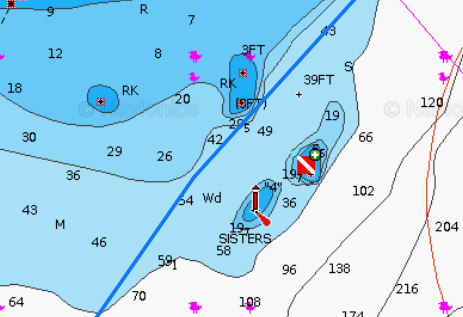
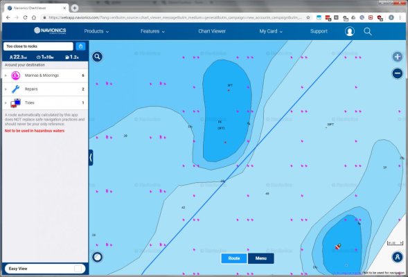
A side note is fully trusting the magic gizmos is not a great idea either, Navionics auto routing can't be fully trusted. Selecting an auto route from mid channel near Foulweather Bluff southbound to Pleasant Harbor Navionics will put you uncomfortably close to the two unmarked rocks NW of the unmarked Sisters rock.
Looking at three charts, NOAA raster, NOAA vector and Navionics there are clearly 3 hazards in the area of Sisters rocks. Only one is marked, the southern Sisters rock. Unmarked are the northern Sisters rock and two rocks to the NW of the unmarked Sisters rock.
Looking out for aids to navigation is important, but it's not enough. We still need to study our charts...

Remember to zoom in on electronic charts, especially when near marked hazards.
Reminds me of the Volvo Ocean Race, when one of the multi million dollar yachts with world class sailors aboard was destroyed by hitting a reef at night.
We spend quite a bit of time close to rocks photographing seals and birds, and there can be some significant differences between what the electronic chart says (even when zoomed in) and what the depth sounder says.
Remember to zoom in on electronic charts, especially when near marked hazards.
Murray, it's also a little reminiscent of that BC ferry that banged a rock and sunk up your way. Was it at the lower end of Grenville channel?
Yup...apparently due to an inadequate watch during shenanigans on the bridge.
Remember to zoom in on electronic charts, especially when near marked hazards.
Reminds me of the Volvo Ocean Race, when one of the multi million dollar yachts with world class sailors aboard was destroyed by hitting a reef at night.

That's where the latest split screen version of opencpn is great.
One half of the screen zoomed out and the other zoomed in, both showing vessel position .
https://opencpn.org/OpenCPN/about/ver500.html