You are using an out of date browser. It may not display this or other websites correctly.
You should upgrade or use an alternative browser.
You should upgrade or use an alternative browser.
Backing Into Slip
- Thread starter kartracer
- Start date
The friendliest place on the web for anyone who enjoys boating.
If you have answers, please help by responding to the unanswered posts.
If you have answers, please help by responding to the unanswered posts.
menzies
Guru
Capt.Bill11
Guru
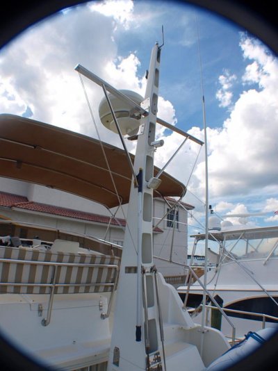
Do you have s flybridge? Most of the time with practice you come to just "feel" where the corners of the boat are. Sort of like driving a big car or truck.
The only way to know where you need the camera to be mounted is to get one and temporarily hook it up and move it around to see where it needs to be for the picture you want. In some cases you need two cameras. One to show each corner.
The only way to know where you need the camera to be mounted is to get one and temporarily hook it up and move it around to see where it needs to be for the picture you want. In some cases you need two cameras. One to show each corner.
sea hag
Veteran Member
I have single helm station on flybridge with blind stern, and narrow slip. Dangerous to impossible for me to back in slip alone. I mounted single camera viewing stern starboard rear transom corner. Being right handed, and driving concrete trucks in my youth using mirrors for backing I find this setup more intuitive for me. Some folks mount screen for viewing as helmsman faces the stern, so like driving forward. Individual tastes. Two cameras with split screen would certainly work. Whatever it takes to make it fun !
Giggitoni
Guru
- Joined
- Jun 21, 2008
- Messages
- 2,092
- Location
- United States
- Vessel Name
- Mahalo Moi
- Vessel Make
- 1986 Grand Banks 42 Classic
I don't have a backup camera. However, I know that some cameras have a feature which allows the user to have a "reversed" image. Much like backing a car with rear view or side mirrors. Easier, for some, to adapt.
I usually keep backing until I hear teak cracking and snapping...
I usually keep backing until I hear teak cracking and snapping...
Moonstruck
Guru
- Joined
- Nov 27, 2008
- Messages
- 8,276
- Location
- USA
- Vessel Name
- Moonstruck
- Vessel Make
- Sabre 42 Hardtop Express
I usually keep backing until I hear teak cracking and snapping...
Ray, that's what I call parking by ear.

mbevins
Guru
Ray, that's what I call parking by ear.
Or as I say "By the braille method"
Magnawake
Veteran Member
Its a feel thing for me getting close. I will sometimes use the outter pile to pivot around on if the wind is blowing. That (backing) part is the most hairyst thing about operating the boat. A camera would just distract me and take my attention away. My wife and I have a system that works pretty well. She says, back, back, back, then if I need to turn one way or another, she says, clockwise or counter clockwise. That way I know which way to turn the boat as I am backing up. The clockwise, counter clockwise method is the same regardless of how you are standing or looking. Then she says , your in the slip, slow down, slowdown, stop. Works everytime unless people are on the dock shouting and I cant hear her giving me instructions. I have thought about a camera running through me I pad. Woudnt be a bad idea.
Gabe n Em
Guru
Works everytime unless people are on the dock shouting and I cant hear her giving me instructions.
We have a guy down the dock who has a pair of bluetooth headsets to alleviate exactly this issue.
In the last years o' his driving... My grand dad had 14 inch flex spring "curb scraper/sounders" sticking off all four corners of his 1952 Chrysler car's shinny chrome bumpers... ya might try that! Of course you could always go into dock slips frontwards...
I don't own boats without flying bridge. Do most all piloting from the bridge... and 99.99% docking from there... Never have experienced need for a camera.
I don't own boats without flying bridge. Do most all piloting from the bridge... and 99.99% docking from there... Never have experienced need for a camera.
O C Diver
Guru
- Joined
- Dec 16, 2010
- Messages
- 12,878
- Location
- USA
- Vessel Name
- Slow Hand
- Vessel Make
- Cherubini Independence 45
Lot to be said for a stern docking station. Single lever engine control, small black lever on the side controls the rudder through the autopilot, and bow thruster control is mounted on top. This could probably be put on many types of trawlers.

Ted
Ted
sunchaser
Guru
- Joined
- Apr 9, 2008
- Messages
- 10,197
- Location
- usa
- Vessel Name
- sunchaser V
- Vessel Make
- DeFever 48 (sold)
We have a guy down the dock who has a pair of bluetooth headsets to alleviate exactly this issue.
This is what my wife and I use for docking situations. Ear Tec by brand name. Better than a camera in that all the pilings, protruding bolts or stanchions get mentioned to the skipper. As well as distances to stop go forward etc. Our boat has excellent sight lines from either helm but the stop now command is nice to hear.
These units are quite common and sometimes used by those who have multiple docking stations since there frequently seems to be tight quarters issues on larger vessels. Have some friends with a large Nordhavn equipped with 5 docking stations, their Ear Tecs are in constant use.
Last edited:
We use headphones as well. Don't get voice activated because wind noise will over power them. Full duplex is best because one person can interrupt the other. Don't use them much for backing. That is my job.
I can see out one corner of the stern but cant see the swim platform. It doesn't matter because I know where it is and as long as I can get one cheek of the boat in the proper position the rest of it must follow.
I can see out one corner of the stern but cant see the swim platform. It doesn't matter because I know where it is and as long as I can get one cheek of the boat in the proper position the rest of it must follow.
We have a set of headphones that are VOX but we don't use them at our home slip. We have a better system--my wife keeps her mouth shut until I'm in the slip unless there's an emergency. .
I can't see the stern but can see along the port side. I know if the port side is just off the finger pier that I have lots of room on the other side. I painted a black/yellow rectangle (3'X6") on the dock, opposite the helm. When I'm that far back I know I'm in far enough.
At that point my wife steps off onto the dock and yells "I'm off" so I know she's on the dock.
I've thought about a backup camera but I don't want my attention divided between the screen and what my eyes are telling me about where the boat is in the slip.
AusCan
Guru
- Joined
- Jul 15, 2012
- Messages
- 3,218
- Location
- Australia
- Vessel Name
- Kokanee
- Vessel Make
- Cuddles 30 Pilot House Motor Sailer
I don't back into my slip, even though the vision is better than docking bow in due to a relatively high bow.
I was always concerned about hitting the corner of the finger when making the turn into the slip while singlehanded. What I've done to alleviate this issue is installed a 6 foot flexible flag on the corner of the finger. This makes it very easy to see, and also will show me what the wind is doing.
Perhaps something like this may work for backing in, if your vision is obscured rather than totally blocked. Low tech & cheap.
Last edited:
We have a camera. It's dual purpose, for security and for docking assistance.
We also have a back-up camera on our SUV. We didn't ask for it, but now that we have it, we absolutely love it. Far more than watching for other cars is watching for people walking behind you in parking lots.
We also have a back-up camera on our SUV. We didn't ask for it, but now that we have it, we absolutely love it. Far more than watching for other cars is watching for people walking behind you in parking lots.
Besslb
Guru
We do like Magnawake. Tom has me in the cockpit giving directional cues if needed, then distances when we get close, "10ft, 5ft, stop", then I step off to the dock to secure the boat. I have a backup camera in my car, and at first it was super distracting, changing the life long habit of backing....but now I love it.
sunchaser
Guru
- Joined
- Apr 9, 2008
- Messages
- 10,197
- Location
- usa
- Vessel Name
- sunchaser V
- Vessel Make
- DeFever 48 (sold)
This past cruising season we have backed in to many different "new" slips when the harbor master says "we have no starboard ties." A camera is second best to a voice in the ear when doing this especially with strong swirly harbor currents as often found in AK.
In Powell River the marina has very narrow access and we found backing for a hundred yards or so was easiest but challenging. Love those twins!
In Powell River the marina has very narrow access and we found backing for a hundred yards or so was easiest but challenging. Love those twins!
Liberty2015
Senior Member
- Joined
- Aug 1, 2015
- Messages
- 196
- Location
- Australia
- Vessel Name
- Liberty
- Vessel Make
- 57 foot Halvorsen
I had installed electronic morse controls , with these I installed a wired remote control which has a 5 metre lead. This allows me to stand on the back deck and back the vessel ,and I have full vision and control of the two stern corners of the vessel.
I dock the vessel on my own and it is as easy as docking a dingy. I don't have thrusters just the twins and they are very responsive.
We have a camera but found that a distraction and hard to judge distance.
There is nothing like having proper vision and hand eye coordination to assist in judging wind and current.
Cheers Chris D Liberty
Wanderin Star
Veteran Member
Backing into ....
BB: I know, right? I guess some people don't know what the white light on your taillights are for. Or maybe walking around with $$ jn their eyes. And plugged in to their electronics. Another thread.
BB: I know, right? I guess some people don't know what the white light on your taillights are for. Or maybe walking around with $$ jn their eyes. And plugged in to their electronics. Another thread.
BB: I know, right? I guess some people don't know what the white light on your taillights are for. Or maybe walking around with $$ jn their eyes. And plugged in to their electronics. Another thread.
Parents at Walmart or the Grocery who let their little kids wander through the lot as they leave. Guess they haven't grown very attached to them.
dhays
Guru
- Joined
- May 26, 2015
- Messages
- 9,046
- Location
- United States
- Vessel Name
- Kinship
- Vessel Make
- North Pacific 43
Just use two cell phones on speaker
Only good if you always are in range of a cell tower.
cardude01
Guru
- Joined
- Nov 26, 2012
- Messages
- 5,290
- Location
- USA
- Vessel Name
- Bijou
- Vessel Make
- 2008 Island Packet PY/SP

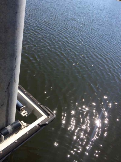
This is the approach to my slip. There is no piling to pivot off of, just this pointy edge with a thin amount of rubber on it.
If I can get past that pointy area and get the stern to the support with the plastic cushion on it I'm fine.
I feel like putting a stick with a flag on the end of the 90 degree pointy edge sticking out. That area always worries me.
Attachments
Liberty2015
Senior Member
- Joined
- Aug 1, 2015
- Messages
- 196
- Location
- Australia
- Vessel Name
- Liberty
- Vessel Make
- 57 foot Halvorsen
Yes can do some damage on that edge. I have a similar slip, but the corner of a floating concrete deck. As a extra precaution I strapped two large fenders that float hard against the edge permanently that will take the edge of it if I happen to come in a bit of line, as long as I take it easy they have assisted and prevented damage.
Cheers Chris D Liberty
Cheers Chris D Liberty
View attachment 45461
This is the approach to my slip. There is no piling to pivot off of, just this pointy edge with a thin amount of rubber on it.
If I can get past that pointy area and get the stern to the support with the plastic cushion on it I'm fine.
I feel like putting a stick with a flag on the end of the 90 degree pointy edge sticking out. That area always worries me.
There are some corner mounts that really do a good job in protecting and rounding the corner. Unfortunately they're in the $100 price range I believe.
Now, the other option I see is some fire hose and tack it to each side of the corner so that it bulges a little in the corner.
Oh just found a corner bumper on Overton's for $80 and $75. You might look around and find some cheaper.

Liberty2015
Senior Member
- Joined
- Aug 1, 2015
- Messages
- 196
- Location
- Australia
- Vessel Name
- Liberty
- Vessel Make
- 57 foot Halvorsen
The wheels are ok, but most of the ones I see , have had too much weight placed upon them and the shafts bend and hence the wheel no longer rotates , and they then scratch the hull. Probably ok if you take it easy.
Cheers Chris D Liberty
Cheers Chris D Liberty
The wheels are ok, but most of the ones I see , have had too much weight placed upon them and the shafts bend and hence the wheel no longer rotates , and they then scratch the hull. Probably ok if you take it easy.
Cheers Chris D Liberty
I like the bumpers better than the wheels and there are some nice bumpers for less than that wheel.
Oh and it's not admitting defeat. It's admitting you may not always be perfect or have perfect conditions and you recognize that.
markpierce
Master and Commander
- Joined
- Sep 25, 2010
- Messages
- 12,557
- Location
- USA
- Vessel Name
- Carquinez Coot
- Vessel Make
- penultimate Seahorse Marine Coot hull #6
One of my nearby neighbors routinely backs into his berth. He has twin engines and bow thruster and does it well (and slowly). Haven't seen him do it single-handed yet. ... Haven't yet seen the need to back in myself, however.
Similar threads
- Replies
- 12
- Views
- 1K