Reply
 
Thread Tools Search this Thread Display Modes
 
Old 05-24-2019, 10:36 PM   #1
TF Site Team
 
koliver's Avatar
 
City: Saltspring Island
Vessel Name: Retreat
Vessel Model: C&L 44
Join Date: Nov 2007
Posts: 5,656
AIS sources and other musings

Over the last 5 or more years, I have used the Boatbeacon AIS App on my android phones.

I live on the waterfront on Saltspring Island, where there is shipping traffic. I frequently check my phone to see who is going past. Sometimes I get a surprising result.
Just now, I noted a towboat taking a self dumping log barge, fully laden, in the wrong direction. Wrong, in the sense that I frequently see loaded log barges heading for Crofton, where there is a ship loading facility that loads up ships bound for Asia with precious BC timber. This time, the barge load is heading South past my home, AWAY from Crofton. Now this one may have come from way up north, the AIS information puts in a destination of Coos Bay Oregon, but no point of origin.
I then loaded up Marine Traffic on my laptop, to see if there is any additional information. No luck there. The speed is different, 5.1 knots on MT v 4.9 on BB, but less descriptive info on MT.
I loaded up the track on BB and can now see that the voyage originated at the log dump in Crofton after all. What can that mean? Was there a contract dispute? Was the load originally destined for Crofton, got there and disagreed on the price so left? Maybe a buyer in Coos Bay wanted to pay more than the PRC?
Curiously, the MT position information was about 5 minutes out of date. As I look out my front window, the tug is a couple of miles down Trincomali channel. BB has it in the correct position, MT has it still up channel from my house. I thought MT was supposed to report position information at least every 2 minutes from a class B, or with a commercial A AIS, much more frequently than that. BB is harder to know just what the frequency of update is, but for BB to be right on the money and MT not, is curious.
Or maybe I just don't now enough about AIS.
__________________
Keith
koliver is offline   Reply With Quote
Old 05-25-2019, 03:02 AM   #2
Senior Member
 
fractalphreak's Avatar
 
City: La Conner WA
Vessel Name: Northwest Dream
Vessel Model: Davis Vashon 42 Trawler (Defever design)
Join Date: Jun 2018
Posts: 318
I have VERY little (so far) experience, but what I do have - watching my own position and track - tells me that MT is not very accurate. I say this in the context of if it doesn't receive updates it leaves the last plot, but doesn't indicate in a visual way it is stale until quite a few hours later. Its only as good as its contributors, I think many of which are shore based listening stations. When we were signing up to make a "fleet" to add our boat to so we could see it on their service, there was a lot of information about contributing data to them and getting membership with enhanced access for doing that.

Our last track out had spots where we didn't show up. When the receivers lost "sight" of us, our position on MT froze. We are using a used antenna and have a poor connection in it someplace, so may not be sending out as strong a signal causing part of the issue. I'm still tracking (groan) that down.

We had a freak out last month - we had left the AIS on at the dock (even though there don't seem to be any stations picking up anything at our marina) and are signed up for notifications when NWD enters or leaves a port of call. Imagine our shock a few days later when we get an email notice the boat has left port! When I looked on MT it showed NWD was in a bay almost 15 miles away from her marina, headed toward shore at 2 kts.. I actually drove down to the marina, playing out the worst in my mind. Of course the boat was fine, in her slip and wondering what all the fuss was about. I checked the GPS position of the slip vs the MT plot and it was EXACTLY north by 12 or 13 nm. I'm guessing some atmospheric blip allowed a corrupted signal to reach a MT connected receiver and so it goes. I turned the d%@$ AIS off for now. That errant plot stayed on MT a full 24 hrs, it turned pale after 10 or 12 I think. We also have noticed every online AIS tracking system seems to have its own combination of data sources. We've only shown up on two that we've tried.

If you're in that great a location, you should set up an AIS receiver at your house and hook it up to the net! You can help MT get those tugs plotted correctly for you!
__________________
"There exist minds that think as well as you do, but differently."
fractalphreak is offline   Reply With Quote
Old 05-25-2019, 03:05 AM   #3
Senior Member
 
fractalphreak's Avatar
 
City: La Conner WA
Vessel Name: Northwest Dream
Vessel Model: Davis Vashon 42 Trawler (Defever design)
Join Date: Jun 2018
Posts: 318
(oh, and then there's the satellites that they use to monitor AIS - YES FROM SPACE! After all we do to try to get 15 or 20 miles on VHF through our island areas, and it turns out they can pick up our AIS with satellites.)
__________________
"There exist minds that think as well as you do, but differently."
fractalphreak is offline   Reply With Quote
Old 05-25-2019, 07:39 AM   #4
Guru
 
South of Heaven's Avatar
 
City: Sharon, Ma
Vessel Name: Slow Lane
Vessel Model: 2005 Silverton 35 Motoryacht
Join Date: May 2017
Posts: 1,167
I had an emtrak AIS class B transceiver (sends and receives) on my last boat. Most of the time it was accurate but sometimes it wasn't.

The worst part was when I'd visually see a huge tug or cruise ship in sight but they either didn't turn on their AIS or didn't even have it. It's just like every other marine navigating instrument, dont rely on it solely. Make sure you have redundancy and use your eyeballs/ears.
__________________
Jason

2005 Silverton 35 Motoryacht
South of Heaven is offline   Reply With Quote
Old 05-25-2019, 08:23 AM   #5
Guru
 
twistedtree's Avatar
 
City: Vermont
Join Date: Jan 2013
Posts: 10,078
The online AIS services are really for amusement only, and are not suitable for any sort of navigation.
__________________
MVTanglewood.com
twistedtree is online now   Reply With Quote
Old 05-25-2019, 09:43 AM   #6
TF Site Team
 
koliver's Avatar
 
City: Saltspring Island
Vessel Name: Retreat
Vessel Model: C&L 44
Join Date: Nov 2007
Posts: 5,656
Quote:
Originally Posted by twistedtree View Post
The online AIS services are really for amusement only, and are not suitable for any sort of navigation.
I have found Boatbeacon useful when I am navigating in a restricted waterway such as Active Pass. With it I can see around the corners and identify the oncoming ferry, learn its speed and predict its course when it does come into view. Also when crossing the Gulf, the CPA of approaching ships is very good to know. Naturally it is always "trust but verify".
__________________
Keith
koliver is offline   Reply With Quote
Old 05-25-2019, 01:13 PM   #7
Senior Member
 
fractalphreak's Avatar
 
City: La Conner WA
Vessel Name: Northwest Dream
Vessel Model: Davis Vashon 42 Trawler (Defever design)
Join Date: Jun 2018
Posts: 318
Quote:
Originally Posted by twistedtree View Post
The online AIS services are really for amusement only, and are not suitable for any sort of navigation.
That's what we've done - it IS fun to put it out to family so if they're curious they can see what we're up to, and MT (if/when we're in coverage) can send them a notice that we've arrived in a port of call.
I'm thinking/guessing there may be areas where users typically see online AIS services seem accurate, I've only really explored MT some to see how it works. What's missing is clear indication if their shore based monitoring station is down (think computer/internet problems), not working well (antenna issues?) as well as indication of actual coverage area and fresh transmission. On MT you can see their shore based stations, and the pins for them do show red (offline), orange (low coverage) and green (online.) You can drill down into each to look at their "coverage area" which is large rectangles and clearly not true reception area. For example, if they figured out a way to only plot targets in bold color if the plot was relevant (within a specified/expected next broadcast time) and shaded the map to subdue areas that were not in a current reception area... I dunno.

When you look at Vancouver, BC, for example, there are a number of stations in a pretty close area - they might be fairly accurate, BUT you have to look at each contact to ensure relevancy.

A quick look at Boat Beacon is that they both seem to rely on an aggregation website (AIShub), but I notice that in the Boat Beacon FAQ they filter out hours old results, at least...The AIShub has at least some of the same reporting stations, so maybe they are all using the same aggregated data? BB also talks about having some stations that are direct feed and have 1 second reporting lag time, but for those that aren't direct "The other stations report once a minute, they accumulate the data over a minute and then send it to us. So on average these reports are 30s behind real time." They go on to say "Boat Beacon interpolates the positions between updates to improve the placement for boats on a slow refresh rate."

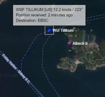
I would think that there are better quality and more frequent updates from the ferries. But just looked at MT at the Washington State ferries in the San Juans. Here is what I found:

Click image for larger version

Name:	MT screen grab.jpg
Views:	45
Size:	36.0 KB
ID:	89158

For those not familiar with the area, this ferry has just passed through the pretty narrow Wasp Passage and is entering San Juan Channel.

Class A AIS is supposed to be broadcasting every 2-10 sec depending on vessel speed. So why is there a 2 minute lag time here? I'm guessing it has to do with reporting stations that don't instantly relay reporting data, and/or lags between what appears to be various data centers reporting to an aggregator, then the aggregator feed back to the various AIS websites...

It would be interesting to see if the paid Boat Beacon app shows similar several minute results for vessels that should be Class A.
__________________
"There exist minds that think as well as you do, but differently."
fractalphreak is offline   Reply With Quote
Old 05-25-2019, 11:05 PM   #8
Senior Member
 
fractalphreak's Avatar
 
City: La Conner WA
Vessel Name: Northwest Dream
Vessel Model: Davis Vashon 42 Trawler (Defever design)
Join Date: Jun 2018
Posts: 318
Quote:
Originally Posted by koliver View Post

Just now, I noted a towboat taking a self dumping log barge, fully laden, in the wrong direction. Wrong, in the sense that I frequently see loaded log barges heading for Crofton, where there is a ship loading facility that loads up ships bound for Asia with precious BC timber. This time, the barge load is heading South past my home, AWAY from Crofton. Now this one may have come from way up north, the AIS information puts in a destination of Coos Bay Oregon, but no point of origin.
Coos Bay isn't a deep water port, but on google earth I see a big water-fed sawmill there.

Natural Resources Canada shows CA lumber princes have been falling all year...https://www.nrcan.gc.ca/forests/indu...t-prices/13309

Is there a point where the price of shipping to China becomes uneconomical, and the margins aren't there to ship?
__________________
"There exist minds that think as well as you do, but differently."
fractalphreak is offline   Reply With Quote
Reply

Thread Tools Search this Thread
Search this Thread:

Advanced Search
Display Modes

Posting Rules
You may not post new threads
You may not post replies
You may not post attachments
You may not edit your posts

BB code is On
Smilies are On
[IMG] code is On
HTML code is Off
Trackbacks are Off
Pingbacks are Off
Refbacks are Off


» Trawler Port Captains
Port Captains are TF volunteers who can serve as local guides or assist with local arrangements and information. Search below to locate Port Captains near your destination. To learn more about this program read here: TF Port Captain Program


All times are GMT -5. The time now is 09:04 AM.


Powered by vBulletin® Version 3.8.8 Beta 4
Copyright ©2000 - 2024, vBulletin Solutions, Inc.
Search Engine Optimization by vBSEO 3.6.0
Copyright 2006 - 2012