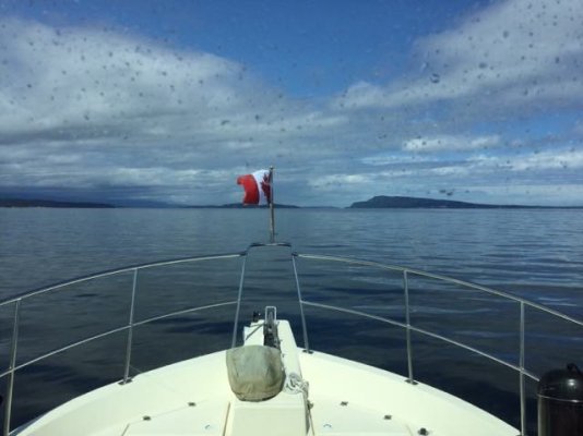
Desolation Sound, 2017

The friendliest place on the web for anyone who enjoys boating.
If you have answers, please help by responding to the unanswered posts.
We are about 30 minutes out from Cattle Pass and I must say this has been one of the most unpleasant crossings of Juan de Fuca I've had. The waves were quite a bit more than forecast, although the wind wasn't too bad. For a while we had 5-6 feet breaking waves at at 3 seconds.


You experience is the fourth I've heard in the past few weeks, including my own on 7/1, where the forecast has been off in the strait.

We are heading up to Roche this friday before heading to BC and will most likely take deception pass.
 
Dave you can always anchor in Mark bay or grab a buoy. when weather is suspect we head toward Texada at 0 dark 30... BC ferries will report weather and sea state on 16. It can be a couple of hour slog across but it beats getting stuck where you don't want to be safe travels
 
Can't say that I'm a local, but just came through there a couple of weeks ago. That stretch between Nanaimo and Comox were transited under similar conditions that you describe are forecast for tomorrow. We thought it would be a piece of cake once the winds shifted to NW, but were hit by a significant NE to E swell the whole way, at times uncomfortable on the beam. Seems as though the tidal currents have an awful lot of effect on those swells and it was a new moon, so lots of current. Never did figure out the "how" and "why" of those swells 'cause it didn't make sense with the wind, but we were (mostly) going downhill from Comox to Nanaimo. It looked like the guys going the other way were doing a lot of bashing into headseas. Hope it's not that way for you...

BTW, we really liked Comox area.
 
The weather station at Sisters Island, will give you a good idea of conditions, you will be facing. About a fifty mile jaunt to Comox, so if it on your nose it won't be a great ride. That area just North of Newcastle, has bit my butt on more than one occasion, coming and going.. Wait for morning, and see how things are, forecasts usually worse than conditions, but not always. FishWeather site show winds fairly light from about 1 to 5 tomorrow afternoon. I have known them to be wrong before also.. Good Luck.
 
Dave you can always anchor in Mark bay or grab a buoy. when weather is suspect we head toward Texada at 0 dark 30... BC ferries will report weather and sea state on 16. It can be a couple of hour slog across but it beats getting stuck where you don't want to be safe travels


I checked with the warfinger here and while they will have another crew here tomorrow, they think that probably they could find a spot for us for the night. Tomorrow doesn't look good but Monday starts to look better.
 
Can't say that I'm a local, but just came through there a couple of weeks ago. That stretch between Nanaimo and Comox were transited under similar conditions that you describe are forecast for tomorrow. We thought it would be a piece of cake once the winds shifted to NW, but were hit by a significant NE to E swell the whole way, at times uncomfortable on the beam. Seems as though the tidal currents have an awful lot of effect on those swells and it was a new moon, so lots of current. Never did figure out the "how" and "why" of those swells 'cause it didn't make sense with the wind, but we were (mostly) going downhill from Comox to Nanaimo. It looked like the guys going the other way were doing a lot of bashing into headseas. Hope it's not that way for you...


BTW, we really liked Comox area.


That is good feedback. I was looking closely at the winds and if they veer a bit to the NNW then that 20 miles of open coastline between Ballenas Islands and Denman Island could be on the receiving end of quite a swell. With a Northbound current, it could get short and steep.

We liked our stay in Comox last year, so we may try for it tomorrow, or if it is going to be unpleasant stay another day here in Nanaimo. If we can't stay at the marina, we can anchor or see about a reciprocal slip at the NYC. Looking at the weather forecast, we may go real conservative and spend another night here, then a night in Comox, then run to Desolation on Tuesday when it is supposed to be relatively quiet.
 
Heading to Comox, if you go up the inside of Denman Island, be aware that they have a new ferry there and there are traffic lights set up to stop other boats until the ferry is at the terminal. Yes, traffic light. You know, like the red and green ones you see when you're driving your car in town. It's a cable ferry and although aft of the ferry the cable should be slack and sunk, they don't want us to get confused and go infront of the ferry so they stop traffic entirely except when the ferry is docked.

Comox is lovely and has some good eateries close to the dock from what I've heard.
 
Thanks Greg. That is a good warning. I came South through there last year and couldn't figure out what those markings were on the chart. As I got close to the ferry crossing I noticed these funny green lights on either side change from green to red. It got me thinking and I slowed. I then heard the ferry captain make a Securite call on 16 and i figured out what it was about a 1/4 short of the crossing. I idled back and waited for the ferry to finish crossing but I had never seen such a thing before.
 
We are currently at Toba Wilderness Marina headed to Squirrel Cove Sunday AM. Full docks here. Great hiking at Toba, black bears galore but scat shows blackberries only, no meat - yet! Nice rain overnight. Cruising conditions look pretty good for next 3 to 4 days.

So long as forecast is for 20 knots or less Nanaimo to Comox is pretty easy. Our don't go point is normally 25 knots (in a bigger boat than the NP 43) but Qualicum Beach area can gust 10 knots above forecast. Don't overlook Henry Bay as an anchorage. It is a Comox locals favorite and calm in gales - northwest tip of Denman.
 
Thanks Sunchaser.

We decided to head to Comox this morning. The winds out of the South weren't as bad and it was calm in Nanaimo. About 9:00 am the winds shifted out of the North at over 20 knots. I didn't get as far as I would have like before that happened but am trying to use the shore to block as much of the seas as I can.

Comox said that most of the boat they had there last night are staying put due to the weather.
 
About 45 minutes ago, the water started to flatten out. Now it is like a big lake.

Image1502651629.882665.jpg

Sorry about the salt spots on the windshield. I just cleaned it last night but was taking spray over the top of the Pilothouse today,
 
We are heading south on the east side of Hornby. Much nicer day than was forecast.
 
Reality is, it is a third the size of San Pablo Bay and in summer looks like the Red Bull Flugtag in another thread.
:eek:


Desolation? A third the size of San Pablo Bay?

Sorry, [emoji4] you must be thinking of the federal Marine Park known by that name. A quick measure of San Pablo Bay shows it to be about 10 miles by 9 miles. The cruising area known as "Desolation" extends from Campbell River to the mouth of Toba inlet, 26 miles; and from Savary island to the north end of Sanora island, 36 miles. It includes all the inlets, islands, shores, narrows and rapids of the area.

If you want to argue that Quadra and Sonora islands aren't part of it, then you are still looking at 20 x 24 nautical miles. Still leaves almost 500 square miles compared to less than 100 of San Pablo Bay. San Pablo Bay seems to be lacking about 8 main islands and a dozen significant inlets too, presuming you only recognized the smaller Desolation cruising area.

It's amazing what can be learned on Wikipedia. Not all of it is true and not all of the truth is there.

Come on up and cruise some summer. Lots of Charter boats available so you needn't bring your own boat all the way up the open coast. There are lots of uncrowded areas too if you want to stay away from the Flugtag group.[emoji16]
 
We are currently at Toba Wilderness Marina headed to Squirrel Cove Sunday AM. Full docks here. Great hiking at Toba, black bears galore but scat shows blackberries only, no meat - yet! Nice rain overnight. Cruising conditions look pretty good for next 3 to 4 days....
Now I know where you, and several others, are enjoying the wilderness. Found some youtube vids, mostly from motoring sailboats, revealing the stunning remote scenery,quite reminiscent of NZ South Island sounds. You have beautiful cruising grounds.
 
Greg S; said:
Come on up and cruise some summer. There are lots of uncrowded areas too if you want to stay away from the Flugtag group.
Lol, yeah, I should go check it out sometime. Maybe when I get done this Vancouver gig of house and pet sitting for my kids who are out in Nootka…and like I said; semantics.

You, me and a dozen or so others,(Retreat, Sunchaser, Gwaii Haanas, Northern Spy etc.) know what you are talking about, but most never put a bow in Grace, Trevenen, Lancelote, Okeover or horrors, snuck into Theodosia or up past Walsh Cove and around Dean Point into Pryce in the middle of winter. They only know Desolation Sound as Eveleigh and Tenedos in July. Maybe Teakern Arm.

Just like most scoot right by Jervis Inlet without a hint of what’s tucked up there.

Even Mrs. (Ms? geeze, I don’t know any more) Hays has a better handle on DS than Jimmy Pattison, who’s been spilling good scotch up there for 35 years, without ever jumping in the drink. Used to see Trev Deeley’s 57 Canoe Cove up there. Never saw him on deck, or with the TV off.

My first job, at 16, I worked out of Lund, running “groceries” to all the government wharves up and down both sides of the Redondas. Probably have great grandkids in Church House or Bishop Landing. Mansons? Maybe.

Trivia;
Desolation Sound Marine Park is Provincial not Federal and was created (along with the most of the land and marine Provincial parks) by the 70s “Socialist” Gov. Don Lockstead, a once Powell River Mayor, was the push behind Desolation Sound Marine Park.

Anyway, back on topic, Dave done good today. Experienced typical August in Georgia Strait. Flat calm and unpredictable. Tomorrow they’ll be skinny dippin’ in the salty hot tub and Oliver will be working his new stabilized nocs.

Dave, toss a banana to that monkey on Ascente, will ya.
 
Last edited:
Greg S; said:
The cruising area known as "Desolation" extends from Campbell River to the mouth of Toba inlet, 26 miles; and from Savary island to the north end of Sanora island, 36 miles. It includes all the inlets, islands, shores, narrows and rapids of the area.
It was late and I got carried away on my soap box there.

I meant to also point out that Desolation Sound being “known as,” is yes, known as but isn’t. Like Lions Bay to Steveston to Maple Ridge and Langley is known as Vancouver but isn’t.

Campbell River is in Discovery Passage and Savary Is. is in Georgia Strait.

Campbell River has been “known as” The Salmon Capital of the World. Never was. Just sounded really catchy. Now they like to be known as the eco-tourism hub.
Flavour of the day.

Interlopers are trying out the name Sayward by the Sea. Warm and fuzzy to some, retch inducing to others.

Tourists to Telegraph Cove are told they are in Blackfish Sound. They aren’t but it sounds sexier.

Just trying to respect history and the multi-generation locals, here.
The attached pic more accurately “depicts” Desolation Sound.
 

Attachments

  • Real DS.jpg
    Real DS.jpg
    38.4 KB · Views: 86
The drop in the NW wind came right on schedule, just didn't drop as much as forecast. We took on 100 gallon of fuel and left Comox around 8:30. The crossing was easy with just a short section of 2 foot waves. Those flattened out when got into the lee of Savary Island.

Very pleasant day so far.
 
I have not had any cell service for a bit. Turns out my phone can get just a touch of cell service at high tide in Roscoe Bay. Mid to low tide, doesn't work.

We had a nice trip to Roscoe Bay yesterday. It was very nice heading up the coast from Lund into Desolation Sound. We had been to Roscoe Bay last year and wanted to go again. It was reasonably crowded, but not as much as last year. We arrived in the middle of the afternoon. After most folks had most folks had moved and found a new anchorage.

Went for a hike to Black lake and then went swimming from the boat. Enjoyed our spot so much we decided to stay another day. We are stern tied to the South side of the inner portion of Roscoe Bay. It is a lovely spot.

My wife would like to head over to the Prideaux Haven area tomorrow for a couple of days. Likely we will try for Melanie Cove although I like Laura Cove better. Hopefully it isn't too crowded. After that, not sure. Koliver is around here somewhere and I would love to meet up with him, but since cell phone service is spotty at best and I am at the whims of my wife, hard to say. He is smarter and avoiding the spots crowded by Americans. I must say though, last night we were just one of two or three boats from the US here. Most were from Canada. A few more Americans of the US flavor came in this afternoon however.
 
BTW, my wife has a lot of good ideas. A couple weeks ago we were visited by a couple while we were anchored out in Gig Harbor. They were cruising around the harbor in their dinghy and stopped to ask some questions about our boat.

They had an umbrella mounted on their little console RIB as it was sunny for a change. This gave my wife an idea. She was bound and determined to get an umbrella for our boat deck. I thought it was a stupid idea but rather than say that I simply said, "Sounds great, find what you like." She found a Magnum (same folks as make the grill) umbrella and I ordered it for her.

This afternoon the sun finally appeared. I have that stupid umbrella mounted on the port rail providing me some pleasant shade from the afternoon sun.

Just about every idea that she has that I consider to be be too stupid, silly, impractical, or just downright embarrassing (an umbrella on a boat!) turns out to be a really, really good idea.
 
Silly Goose, another 42 or 3, is in your area. Dale and Linda aboard. He has rolling chocks. Somebody to chew the fat with if you get bored.
 
Silly Goose, another 42 or 3, is in your area. Dale and Linda aboard. He has rolling chocks. Somebody to chew the fat with if you get bored.


I will keep an eye out for them. When in Comox I saw "Pelagio", another NP43 that is owned by Jim. We happened to dock next to him last year in Comox. He wasn't around his boat when I walked by this time.

We spent yesterday relaxing in Roscoe Bay. Weather has been a bit cool and overcast. It rained last night. However, that hasn't kept us from enjoying the water and swimming.

This morning we will head over to the Prideaux Haven area. Karen wants to go back there. We will see if we can find a spot in either Laura Cove or Melanie Cove.
 
He must be homeward bound. Pelagic was on his way N this spring, we crossed paths 2-3 times. He was headed for the Charlottes. Good to hear that you are having a good time.
 
Seems odd to talk about getting together with DHays, to also be less than 3 miles apart, and to see that it probably won't happen this year.
We are anchored behind Otter Island, one of our favourite spots, and one we keep returning to, as this is our 3rd visit this trip. We had our eldest son and his wife rafted to us on the first 2 occasions, prawning is better here than anywhere else we have been this trip, traffic through the anchorage is light, the sun stays with us late in the day, etc, etc.
This visit began as a "quick stop" while we wait for the 20knots SE reported by our son, just south of Savary at 12:00, to abate. We now have a social engagement back at Scott Point on Saturday, so should get a move on.
 
If I didn't have a weak-ass electric motor for my dinghy, I would have come down to visit. We had some strong winds today, hopefully they will abate for your trip back.
 
Have fun Dave! Desolation Sound can get a little crazy with all the boats. Be Safe!
 
Have fun Dave! Desolation Sound can get a little crazy with all the boats. Be Safe!


Thanks. So far my wife and I have a bit of an argument going. She says that so far there are only about 1/2 the boats in the areas as last year. I'm thinking it is closer to 2/3 of the boats we saw last year.

Still lots of boats for sure, but still room for more. Far fewer US boats than last year. I'm thinking the BC fires and resulting smoke may have kept the US boats from coming this far North. The Puget Sound getting inundated with the smoke the week before we left may have been a huge blessing for us.
 
Dave, I know you are watching the calendar and weather with the 23rd in mind so I’ll toss one out for next year. When I saw you in Teakerne, I was hoping you would come out and head up Lewis, then go into https://mapcarta.com/24694964 but you fooled me.

Anyway next year when you decide to tackle Gillard Passage you can stop at VD on the way.
dhays; said:
..my wife and I have a bit of an argument going. She says that so far there are only about 1/2 the boats in the areas as last year. I'm thinking it is closer to 2/3 of the boats we saw last year. Far fewer US boats than last year.
Everyone I talk to is telling me the boats are way down this year. Way down.

Folks running on up past Cape Caution are actually hitting places they haven’t stopped in years, because there are unusually fewer boats in previously busy hidey holes. 3 days alone in Fougner Cove probably hasn’t happened in 15 years.

Driven by an enquiry from a pal, out there somewhere, about US vs CA boats, this morning I did an unscientific AIS count. Unscientific because, I’m guessing less than a third of US pleasures and even fewer CA have AIS.

Anyway by rough areas working down the coast:
Shearwater to Nigel Is; CA 10 US 16
Broughtons; CA 4 US 14 FR 1
Blind Channel to Cortes Bay; CA 10 US 18 GB 1 MH 1
Desolation Sound to Von Donnop; CA 9 US 48 MH 3 GB 1 Caymans 1
Nanaimo & S Gulf Islands; CA 29 US 47

Interesting, just across the 49th:
Roche Harbor & Stuart Is CA 4 US 112

FWIW…
 
HW, I really wanted to go to Von Donop this trip, but then I also wanted to go to the Octopus Islands Marine park as well. My wife gets in a rut and I must accommodate her. Hopefully next year I can get her to go further afield.

Teakerne Arm was pretty, but my wife says that having been there once, it isn't necessarily a place she needs to visit again. We got there around 12:45 and dropped the anchor in a bit over 100' of water right off the point where the Provincial Park sign is located. I was able to get a stern tie off a ring mounted in the rock and we seemed pretty secure. Then the wind came up a bit and I wasn't so sure... I had all 300' of chain out but as the wind moved us East then West I could hear and feel the chain dragging on the rocks. The problem was I couldn't tell if it was only the chain or if it was the anchor dragging as well.

We had a nice swim and dinner but after that we decided to move so I could sleep more comfortably. We moved South and then East to the very tip of the Eastern branch of the Arm. There we anchored by ourselves in 30 feet of water with good holding and no need for a stern tie.

My gypsy on my windlass is not a combination gypsy I don't believe. I would love to have 200' of nylon between the end of the chain and the boat. I rarely anchor in deep water, but up here there are some places where I could easily be dropping the anchor in 60' of water. Add the distance to the bow pulpit and a 15' rising tide, and I want more than 300' of chain down.
 
Yesterday we left Teakerne Arm and headed up to the head of Pendrell Sound. We were there last year and loved it but the mosquitoes chased us away. This year we have not noticed many and again Karen wanted warm water.

We anchored at the very end of the Sound about 50 meters from where we were last year. Anchored in about 50' of water, put out 275' of chain, and picked up a stern tie around a huge tree. This year has been a bit of a challenge as I don't have 3 adult kids (counting my son-in-law) to do the stern tie grunt work. Last year I was able to stay on the fly bridge and hold the boat in position while the kids got the stern tie established. This year my wife is having the hold the boat in position and she is still learning how. I have about 400' of Sampson Floatline on a reel and used all of it on that stern tie.

Great spot, great views. Wonderful weather and very nice swimming.
 
Today we left DS and came down to Lund. No reason other than my wife wanted to see Lund. I have found this year that if we reach a location by Noon, it isn't full up yet. As such we left around 7:30am for Lund.

Beautiful weather today. Pendrell Sound was flat calm and we were the only boat moving. Got to Lund around Noon and were able to get a nice spot on the dock. All afternoon it has been filling up and we are completely surrounded by boats now.

Lund is a pretty spot. Had a decent lunch at the Boardwalk Restaurant and likely will have appetizers and drinks at the Lund Hotel Pub later since our lunch was pretty big.

We have about a 40' sailboat rafted next to us that has come down from Alaska on the way to Vancouver. As near as I can tell, it has been a Japanese man doing it solo although he picked up his daughter and her family a bit North for rest of the trip. Gozo, the sailor, doesn't seem to speak English (even the Canadian version) so his daughter was translating for him.
 

Latest posts

Back
Top Bottom