Blaine to Anacortes

The friendliest place on the web for anyone who enjoys boating.
If you have answers, please help by responding to the unanswered posts.
Everyone has their preferences, and I view the Sac Delta as relatively uninteresting compared with say Anacortes to Juneau. But if I had only weekends I'd be doing the same thing. To enjoy the PNW you need weeks at a time, if not months.

What the SF bay is really good for is sailing. The PNW, not so much.
 
Wind in the summer is famous for disappearing along southern coastal BC. But also out in the Pacific Ocean as well. The famous Vic/Maui sailboat race leaving from Victoria BC can often be hit by the doldrums during the race and boats can sit for days being pushed backwards.
 
I can never figure out what people in California do on their boats...

Down here in SoCal we fish, snorkel, swim, and catch lobster while boating 12 months a year. It’s not so bad.
 
Down here in SoCal we fish

My boat is further north than where I live which is in my data you can see. And I live close to a working marina with about 80 % fisherman, sport and commercial. If the winds up here aren't crazy, which most of the time they aren't, you'd be surprised at how many fisherman are out there in rain, snow, and what have you. Hey, they are fisherman first and boaters second.
 
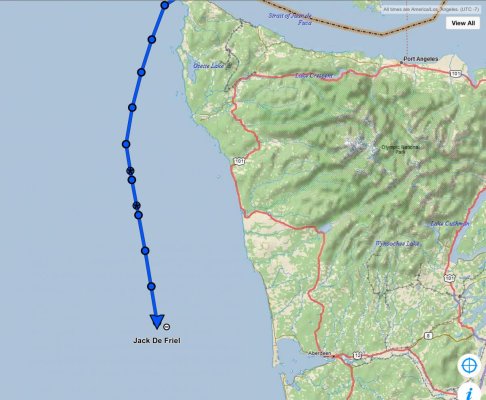
Jack DeFriel left yesterday from Anacortes and made it to Neah. On the way to Newport now, planning to arrive mid-day Sunday. Plan is to be in SFO Wednesday. He reports boat is running great and handling the conditions well.
 

Attachments

  • 9255F84C-6B3C-4527-AE86-BA7EF54CFCB3.jpg
    9255F84C-6B3C-4527-AE86-BA7EF54CFCB3.jpg
    150.9 KB · Views: 70
Check the weather

Wednesday forecast is 25-33 kts, 4’ seas.

I’ve run on 2,000 plus Vessel Assist / TowBoat US calls and I cover the turf you plan on transiting.

Wednesday is a bad plan.
 
First of all. Weather looks bad Wednesday 16. I would not go. Wait for a good window

Second check tides. Leave after high tide. This should give you a push into Anacordes

Chart your path. Use your chart plotter.
 
Folks, boat is already south of Newport Oregon heading down the coast.
 
Distance / Speed / Time Between Points

I am quite shocked to see the number of requests for information related to distance, speed, and time between points that appear in both TRAWLER FORUM and CRUISER & SAILING FORUM.

It appears that people can no longer determine this information from "the charts".

It appears that people have become so dependent on "electronic systems" that they would / will be absolutely lost if and when their electronics fail.

REMEMBER THIS CAVEAT ABOUT "ELECTRONICS" - GARBAGE IN - GARBAGE OUT".

Organizations like the American Sailing Association, the United States Power Squadron and the Canadian Power Squadron have, for years, put on courses so that boaters could travel without necessarily relying on "electronics".

Is it that the people buying these expensive boats today are just too cheap to take the necessary courses to be self-sufficient on the water or are they just trusting that their "electronics" will never fail.

Remember - ANYTHING THAT CAN GO WRONG WILL GO WRONG.

Once something happens is the wrong time to determine "I SHOULD HAVE .."
Have no idea what you are talking about. All I do is turn on navionics on my iPad, touch the my destination, hit the autoroute button and the iPad tells the autopilot were to steer, how far my destination is and what time I will arrive. All I have to do is sit back and take a nap.
 
Kendalk, was not even close to my boat, e.g. several hundred miles away..and was asking experienced members how far it was between Blaine and Anacortes....

Really wish there was not so much sarcastic negativity from some members. Pathetic.
 
I am quite shocked to see the number of requests for information related to distance, speed, and time between points that appear in both TRAWLER FORUM and CRUISER & SAILING FORUM.

It appears that people can no longer determine this information from "the charts".

It appears that people have become so dependent on "electronic systems" that they would / will be absolutely lost if and when their electronics fail.

REMEMBER THIS CAVEAT ABOUT "ELECTRONICS" - GARBAGE IN - GARBAGE OUT".

Organizations like the American Sailing Association, the United States Power Squadron and the Canadian Power Squadron have, for years, put on courses so that boaters could travel without necessarily relying on "electronics".

Is it that the people buying these expensive boats today are just too cheap to take the necessary courses to be self-sufficient on the water or are they just trusting that their "electronics" will never fail.

Remember - ANYTHING THAT CAN GO WRONG WILL GO WRONG.

Once something happens is the wrong time to determine "I SHOULD HAVE .."

You might want to pretend to be a nice guy for a post or two before you jump into the criticism. That is your first post?

Welcome to TF.
 
I have neighbors that built one of those little libraries on a stick by the curb on the street. Because they are old and think that bookstores are closing because people are reading “less” these days.
 
Here is a useful link for the Salish Sea.


NWCRUISING.NET Nautical Miles in the Pacific Northwest, Olympia to Queen Charlotte Strait


Your specific route would be found here:
Nautical Miles From/To Anacortes, NOAA Chart 18400


It gives 33.6 nm and 4.8 hours at 7 knots. Since I usually cruise at 7 knots, it is really handy. The comment about current is important however as well as sea conditions along that stretch. It can be rough depending on wind and current.
Thanks Dave. Interesting site. Disappointed there's no Powell River or Westview, but yet they list Beach Gardens... shrug.
 
Regarding kendalk’s post above ... I agree.
 
If it is 34 miles it is 34 miles at 8 knots and 34 miles at 80 knots, probably still 34 miles at 800 knots.

pete
 
But, if you can get close to the speed of light, it is considerably shorter! Traveling at 582,000,000 knots will make the distance only 1.7 miles. Fuel consumption may suffer, however....
 
Back
Top Bottom