Marquette tow sinks

The friendliest place on the web for anyone who enjoys boating.
If you have answers, please help by responding to the unanswered posts.
Joined
Jan 25, 2013
Messages
1,357
Location
US
Vessel Name
Northern Lights II
Vessel Make
Bayliner 3870
Tow captain I know told me he suspects they were running lite & going to fast. That will suck the boat lower in the water & bottom out if not enough water in channel. When we came thru that area in October there were spots where we had 8' under a boat that drafts 2'. All the hands are safe is the main thing, the CG has closed a 8 mile stretch of the river till the fuel & oil aboard is contained.
http://qctimes.com/news/local/7fb33735-89a6-5e40-9eef-4735351f80f2.html
 
Too bad, looks like a heck of a tug. 45 years old, I wonder if they'd salvage and upgrade it. Glad no one was hurt though.
 
I asked Mike the capt I know who works for Luhr Brothers the same questions he said because of where it's sitting it'll be a pretty easy recovery & that it would be repaired & returned to service. Okie Moore is the outfit that'll raise it Mike thought, said it'll take about 2 weeks, majority of the time spent removing fuel & oil.
 
This Is in my home waters. It sunk about 2 miles upriver from the I-80 bridge over the Miss. The current priority is dealing with the 100,000 gals of diesel and lube oil aboard. I will stop by on my home this afternoon tp take a few pictures. Here is what the local paper has:
Photos: Towboat sinks near LeClaire : Gallery
 
For some reason I was thinking it was farther north than that, up around Clinton. Be nice to have a few hundred gallons of the fuel if I had a way to store it.
 
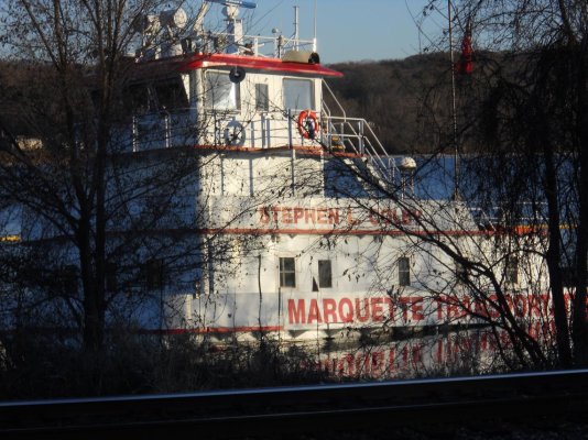
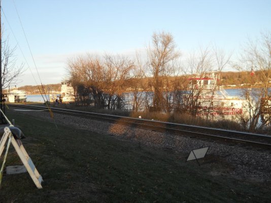
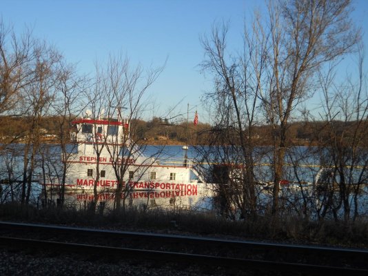
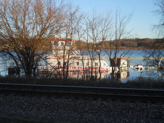
Here are pictures from today. It's hard to see from the pictures, but the tow is sunk in about 25 feet of water. It's not known, or at least released what the tow struck in the river. I don't know in what direction it was headed, but It is headed upstream where it lies. The river in this area is very deep (in the 30 ~ 40 foot range) so it is unlikely that something was lying on the bottom in the channel that could have been struck. Downstream about a half mile, is located one of two Lateral dams that I believe are the only such examples of hazards on the entire upper river. These are relics from the past that enabled steamboats to pass the LeClaire Radids. The other is downstream about 8 miles that enabled steamers to avoid the rapids between Moline IL and Bettendorf IA. at the time of construction (1850's)the Army Engineers lacked the technology to dam the entire Mississippi. So what they did (They in this case was led by Robert E Lee) divided the river into two paths with the use of the lateral dams. At the downstream ends they built dams and locks. When the current Lock and Dam system was built in the 20's and 30's they became obsolete. But they were never removed. I'm guessing the Tow ran over the LeClaire lateral dam. Tow Captains generally represent he utmost in professionalism. But I have seen instances when that wasn't the case. I'm sure well know when the Coast Guard gets done with their investigation. In my mind the lateral dams are not marked very well. But Tow Captains are trained to a very high standard of river knowledge, so it is hard to believe. I stopped to take pictures tonite and wouldn't you know it the site was being picketed by 'On Strike' Salvage divers. Iowa is a right to work state, needless to say they didn't earn any sympathy from me. It really capped my impression when one of the picketers left giving the finger to the emergency response workers on site.
 

Attachments

  • DSCN0599.jpg
    DSCN0599.jpg
    197.4 KB · Views: 177
  • DSCN0604.jpg
    DSCN0604.jpg
    163 KB · Views: 198
  • DSCN0602.jpg
    DSCN0602.jpg
    196.8 KB · Views: 208
  • DSCN0601.jpg
    DSCN0601.jpg
    198.6 KB · Views: 202
I hope the spill isn't too serious.
90,000 gallons of fuel aboard. :confused: Man, that's over 321 tons.
What a brute this old girl is.
The skipper has some splainin to do, I'm sure. I suggest he start drinking heavily.
 
Back
Top Bottom