BDofMSP
Guru
- Joined
- Sep 5, 2013
- Messages
- 908
- Location
- USA
- Vessel Name
- Gopher Broke
- Vessel Make
- Silverton 410 Sport Bridge
Hello. Since I don’t have the luxury of Starlink, I’m not able to post (or read) anything while I’m out in the more remote areas of Lake Superior. This includes Isle Royale, where we were for our recent nine-day trip. As such I was not able to post any updates on the adventure, but I still thought some might want to hear a few details about it so here is a recap.
Day 1 (Fri 6/23) – We faced significant weather forecasted for Saturday so we really wanted to leave ASAP. Unfortunately our guest (my brother) had to work that day, but was able to leave very early and made it to Bayfield by about 2 PM. We were able to cast off before 3 and prepared for an overnight crossing. Winds were very light (5 knots) and seas calm so we prepared for an uneventful voyage. Our cruise speed is typically around 7 knots, as was the case this day. About 8 PM (about 40 miles out in the lake) we slowed to idle speed to grill steaks out on the swim platform, and were thankful for the calm weather. However our (recently added) Sirius XM Weather was showing the predicted weather moving our way, and we pushed it back up and headed on.
Heavy fog rolled in by 9 PM, but with flat calm and nothing on radar or AIS we continued on, rotating thru a four hours on / two off schedule. As it darkened we considered our arrival – it would be about 3:30 AM and we would be faced with a tricky entrance into Washington Harbor, which we’ve never navigated before. Now seemed like a good time to just slow down and arrive closer to dawn, but the weather radar updates showed the promised action continuing to move our way. Since our 7 knots wasn’t exactly a blistering pace, we continued on and decided to simply circle outside until we had sufficient light. This delay was about an hour and a half, and it proved to be a wise choice because a) it remained very foggy and b) winds picked up quite a bit within an hour of our arrival. We were quite glad for the daylight and tied up to the dock at Windigo ranger station.
Day 2 - After breakfast and naps, we decided to put on rain gear and take the hike to Huginnin Cove – about 4 miles round trip … we thought. Well into the hike we finally realized that the measurements were for through hikers, and they were one way distances. Wet, sweaty, and covered with mosquitos we trekked on and completed the loop, starving and thirsty by the time we got back. Rain had fallen off and on all day, and winds and rain definitely picked up overnight, so we were glad to have the dock for our first night.
Day 3 – on Sunday weather continued to be rough. We took the dinghy down the harbor to explore some of the islands and shipwrecks we’d passed coming in. It was quite rough as we approached the open lake, and we got pretty wet, although it was cool to see the old cabins and fish camps from when the island was settled. With no protected anchorage available, we decided to spend another night at the Windigo dock, and took advantage of the showers there.
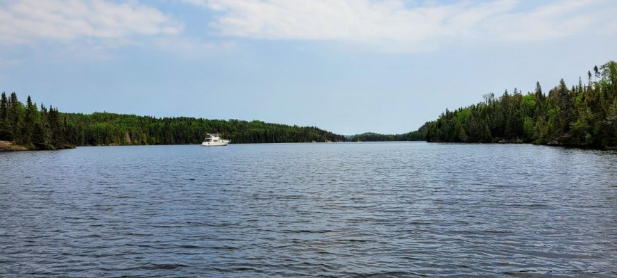
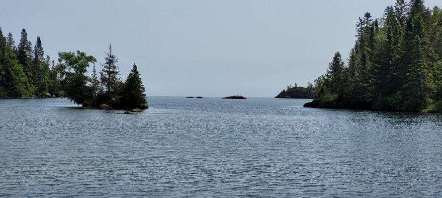
Day 4 – with 5 to 15 forecast we decided to make our way to Chippewa Harbor, which is about a 5 hour cruise at our speed. It was overcast but calm, which was GREATLY appreciated as we entered the harbor. The entrance requires a well set “S” curve between small rock islands and submerged reefs, but with light winds and lookouts on the bow it was straightforward. The harbor itself has two sections, one immediately on entering (where there is a camp and a shallow dock), and a second which is through yet another very narrow (but straight) passage. The second section is completely protected by weather from any direction, and is stunningly isolated and beautiful. We saw only one other boat that whole day – a smaller fishing boat that made its way back for a look but didn’t stay. Unfortunately we had a lot of smoke from Canada fires that day, so not many pictures were taken.
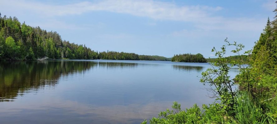
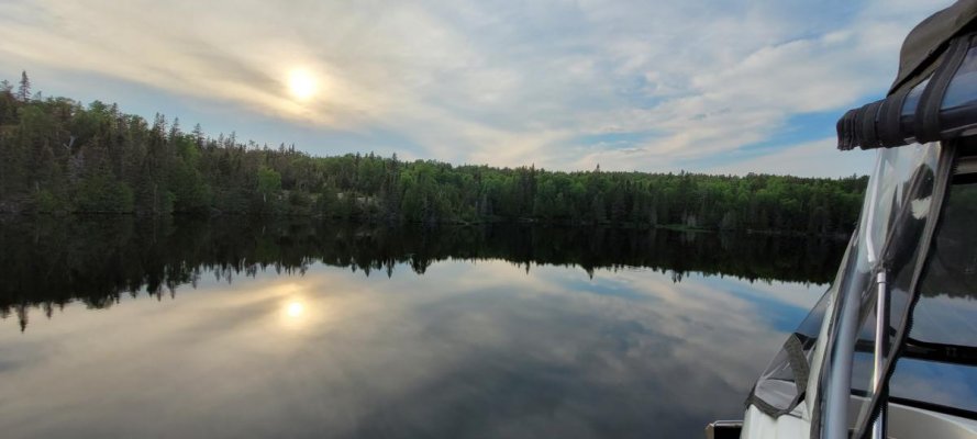
Day 5 – a much sunnier day, we dinghied over to a couple of different portages and hiked to some remote lakes (confirming our distance in advance this time!). Both Lake Whittlesy and Lake Mason provided great hikes and beautiful scenery, and the little smoke haze that remained provide some great sunset light too. A couple shots attached.
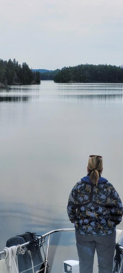
Day 6 and 7 – with 5-15 from the east predicted, we headed to Tobin Harbor. On the way out of Chippewa we were able to get a couple shots to give a sense of navigating the entrance. The trip to Tobin was also calm and short, about 3 hours, but somewhat foggy. The entrance there is also a bit challenging, but much easier – avoiding float planes might be the biggest variable. Tobin is on the back side of the peninsula between it and Rock Harbor, which is where the other ranger station is located and most of the ferry traffic arrives and deposits visitors (hence the float planes). So while it also is protected and beautiful, it’s less isolated.
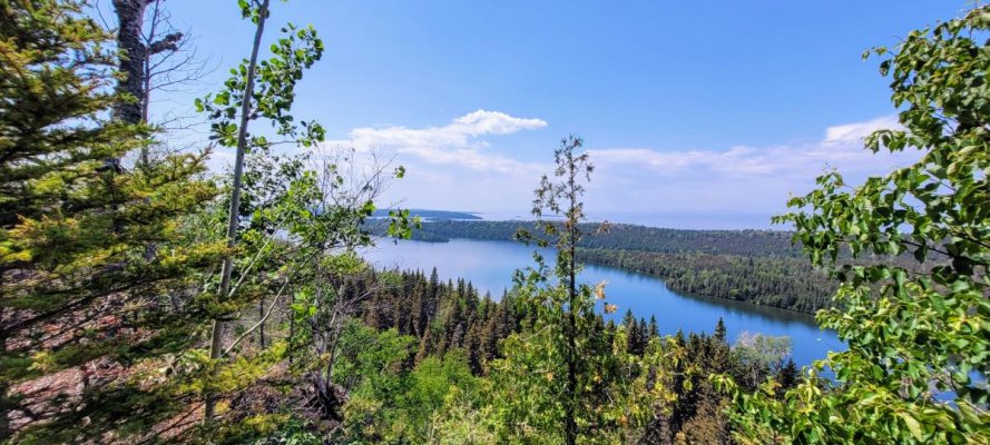
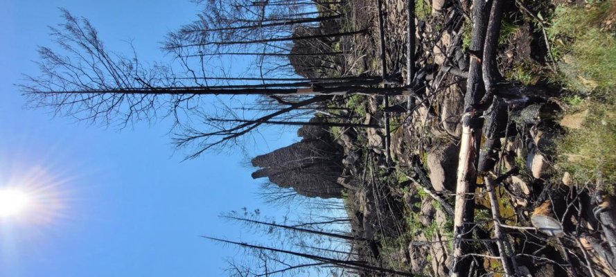
That said, there are lots of hikes to take from here, and so we did. One that was short and very worthwhile was to Lookout Louise. The trail travels through area that was recently burned in a wildfire, so it gives a very different view from the exceedingly green landscape everywhere else. It also passes Monument Rock, which is simply a very large tall rock, but impressive nonetheless. The view from the overlook is also fantastic (and one of the very few places that you can get a cell signal there!). Pics attached.
On day 7 we had our only mishap of the trip. We needed to run the generator go charge batteries and use the microwave, and while it started just fine, it died within 20 seconds. Clearly since it started and ran, something was telling it to shut down. Upon inspection I found that a wiring harness had been chafing against the exhaust temp sensor and had broken it off. The sensor is surrounded by ceramic and sits in a metal housing, and unfortunately the ceramic had broken into several chunks. With some glue and wire and persistence we got it to hold together and in place, and it operated fine for the rest of the trip. Replacement arrives Friday.
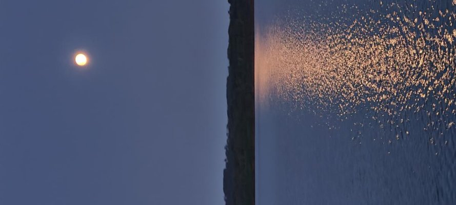
Day 8 – in order to put a little distance toward home under the hull, we headed off to Siskiwit Bay, about 5 hours. It was very foggy the entire trip, and we were frankly concerned about having to find an anchorage with very little visibility. But with fortune on our side, the fog cleared just as we entered the bay and we saw that we had the entire place to ourselves anyway. We took the dingy ashore and found a rock beach littered with agates, and we also “swam”. I forgot to mention that water temps in these bays were about 58 degrees, so while we were in the water most days, we were not in the water for very long at all. Oh, and we did get the supermoon that night!
Day 9 – my brother needed to get home for work, so we left dark and early about 4 AM. Our crossing home was flat calm the entire way, but dense fog. We did find ourselves on a collision course with a 700’ freighter at one point, but had plenty of advance notice from AIS and radar to make adjustments. His closest point of approach was about 5 miles so no concerns. Fog persisted until we hit the Apostle Islands, and fourteen and a half hours after departure we arrived in Bayfield exhausted but quite satisfied. As a note, we were extremely lucky we came home when we did. Lake Superior was hit with tremendous thunderstorms the next afternoon, and we would have been fully in them. Many boaters were radioing for support that day and Boat US, the USCG, and private boaters were all busy rendering assistance.
Hopefully some of you find some things of interest in these narratives. I always appreciate hearing other’s adventures and often learn something.
BD
PS - we burned about 220 or so gallons of fuel on this trip. I don't have the hours records in front of me but I think it was about 43, plus gen usage. I'll update that next week when I'm back to the boat.
Day 1 (Fri 6/23) – We faced significant weather forecasted for Saturday so we really wanted to leave ASAP. Unfortunately our guest (my brother) had to work that day, but was able to leave very early and made it to Bayfield by about 2 PM. We were able to cast off before 3 and prepared for an overnight crossing. Winds were very light (5 knots) and seas calm so we prepared for an uneventful voyage. Our cruise speed is typically around 7 knots, as was the case this day. About 8 PM (about 40 miles out in the lake) we slowed to idle speed to grill steaks out on the swim platform, and were thankful for the calm weather. However our (recently added) Sirius XM Weather was showing the predicted weather moving our way, and we pushed it back up and headed on.
Heavy fog rolled in by 9 PM, but with flat calm and nothing on radar or AIS we continued on, rotating thru a four hours on / two off schedule. As it darkened we considered our arrival – it would be about 3:30 AM and we would be faced with a tricky entrance into Washington Harbor, which we’ve never navigated before. Now seemed like a good time to just slow down and arrive closer to dawn, but the weather radar updates showed the promised action continuing to move our way. Since our 7 knots wasn’t exactly a blistering pace, we continued on and decided to simply circle outside until we had sufficient light. This delay was about an hour and a half, and it proved to be a wise choice because a) it remained very foggy and b) winds picked up quite a bit within an hour of our arrival. We were quite glad for the daylight and tied up to the dock at Windigo ranger station.
Day 2 - After breakfast and naps, we decided to put on rain gear and take the hike to Huginnin Cove – about 4 miles round trip … we thought. Well into the hike we finally realized that the measurements were for through hikers, and they were one way distances. Wet, sweaty, and covered with mosquitos we trekked on and completed the loop, starving and thirsty by the time we got back. Rain had fallen off and on all day, and winds and rain definitely picked up overnight, so we were glad to have the dock for our first night.
Day 3 – on Sunday weather continued to be rough. We took the dinghy down the harbor to explore some of the islands and shipwrecks we’d passed coming in. It was quite rough as we approached the open lake, and we got pretty wet, although it was cool to see the old cabins and fish camps from when the island was settled. With no protected anchorage available, we decided to spend another night at the Windigo dock, and took advantage of the showers there.
Day 4 – with 5 to 15 forecast we decided to make our way to Chippewa Harbor, which is about a 5 hour cruise at our speed. It was overcast but calm, which was GREATLY appreciated as we entered the harbor. The entrance requires a well set “S” curve between small rock islands and submerged reefs, but with light winds and lookouts on the bow it was straightforward. The harbor itself has two sections, one immediately on entering (where there is a camp and a shallow dock), and a second which is through yet another very narrow (but straight) passage. The second section is completely protected by weather from any direction, and is stunningly isolated and beautiful. We saw only one other boat that whole day – a smaller fishing boat that made its way back for a look but didn’t stay. Unfortunately we had a lot of smoke from Canada fires that day, so not many pictures were taken.
Day 5 – a much sunnier day, we dinghied over to a couple of different portages and hiked to some remote lakes (confirming our distance in advance this time!). Both Lake Whittlesy and Lake Mason provided great hikes and beautiful scenery, and the little smoke haze that remained provide some great sunset light too. A couple shots attached.
Day 6 and 7 – with 5-15 from the east predicted, we headed to Tobin Harbor. On the way out of Chippewa we were able to get a couple shots to give a sense of navigating the entrance. The trip to Tobin was also calm and short, about 3 hours, but somewhat foggy. The entrance there is also a bit challenging, but much easier – avoiding float planes might be the biggest variable. Tobin is on the back side of the peninsula between it and Rock Harbor, which is where the other ranger station is located and most of the ferry traffic arrives and deposits visitors (hence the float planes). So while it also is protected and beautiful, it’s less isolated.
That said, there are lots of hikes to take from here, and so we did. One that was short and very worthwhile was to Lookout Louise. The trail travels through area that was recently burned in a wildfire, so it gives a very different view from the exceedingly green landscape everywhere else. It also passes Monument Rock, which is simply a very large tall rock, but impressive nonetheless. The view from the overlook is also fantastic (and one of the very few places that you can get a cell signal there!). Pics attached.
On day 7 we had our only mishap of the trip. We needed to run the generator go charge batteries and use the microwave, and while it started just fine, it died within 20 seconds. Clearly since it started and ran, something was telling it to shut down. Upon inspection I found that a wiring harness had been chafing against the exhaust temp sensor and had broken it off. The sensor is surrounded by ceramic and sits in a metal housing, and unfortunately the ceramic had broken into several chunks. With some glue and wire and persistence we got it to hold together and in place, and it operated fine for the rest of the trip. Replacement arrives Friday.
Day 8 – in order to put a little distance toward home under the hull, we headed off to Siskiwit Bay, about 5 hours. It was very foggy the entire trip, and we were frankly concerned about having to find an anchorage with very little visibility. But with fortune on our side, the fog cleared just as we entered the bay and we saw that we had the entire place to ourselves anyway. We took the dingy ashore and found a rock beach littered with agates, and we also “swam”. I forgot to mention that water temps in these bays were about 58 degrees, so while we were in the water most days, we were not in the water for very long at all. Oh, and we did get the supermoon that night!
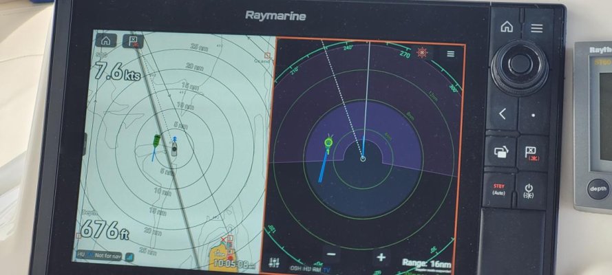
Day 9 – my brother needed to get home for work, so we left dark and early about 4 AM. Our crossing home was flat calm the entire way, but dense fog. We did find ourselves on a collision course with a 700’ freighter at one point, but had plenty of advance notice from AIS and radar to make adjustments. His closest point of approach was about 5 miles so no concerns. Fog persisted until we hit the Apostle Islands, and fourteen and a half hours after departure we arrived in Bayfield exhausted but quite satisfied. As a note, we were extremely lucky we came home when we did. Lake Superior was hit with tremendous thunderstorms the next afternoon, and we would have been fully in them. Many boaters were radioing for support that day and Boat US, the USCG, and private boaters were all busy rendering assistance.
Hopefully some of you find some things of interest in these narratives. I always appreciate hearing other’s adventures and often learn something.
BD
PS - we burned about 220 or so gallons of fuel on this trip. I don't have the hours records in front of me but I think it was about 43, plus gen usage. I'll update that next week when I'm back to the boat.
Attachments
-
 Chippewa Harbor.jpg102.1 KB · Views: 27
 -
 Lake Whittlesey.jpg94.2 KB · Views: 28
 -
 sunset.jpg57.2 KB · Views: 26
 -
 chippewa entrance.jpg54.1 KB · Views: 30
 -
 chippewa entramce 2.jpg117.1 KB · Views: 24
 -
 overlook.jpg173.4 KB · Views: 23
 -
 burnt rock.jpg156.7 KB · Views: 23
 -
 supermoon.jpg66.8 KB · Views: 24
 -
 freighter approach.jpg75.6 KB · Views: 24